

Contents of this page may be automatically translated, we take no responsibility for the accuracy of the translation. Feel free to contact our customer support centre if you have any questions.
This service meets the requirements of the EU Inspire Directive and shows raster images of Sweden which visualize the shape of the terrain in two variants, one slope image and one hill shading image. The product name in Swedish is Markhöjdmodell Visning.
 About this product
The product is based on height data from the National Elevation Model and visualizes the terrain in the form of raster images, slope and shading. The service also contains a layer of information about the time of collection, origin and method of data collection.
Presentation of the Information Layers
Click on the pictures to enlarge them.
Origin and quality
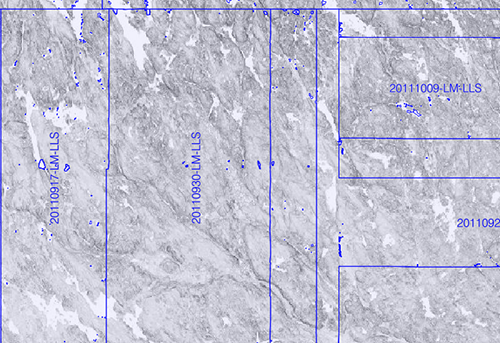
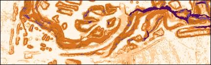
The layer shows the time, origin and method for collecting elevation data as a text for each delimited area.
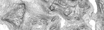
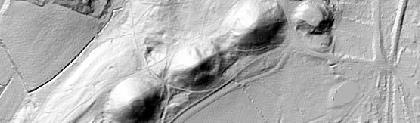
Terrain slope, grey tone
The layer contains a raster image in grayscale where each pixel is colored according to its calculated slope value.
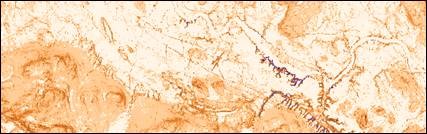
Terrain slope, brown tone
The layer is a raster and has been developed in order to visualise areas with potential soil and rock stability problems. Presented in brown and purple tones.
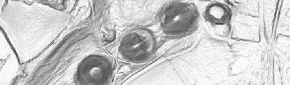
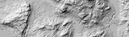
Terrain shading
The layer contains a raster image in grayscale that was produced by illuminating a height model with a simulated light source.
Maintenance and update frequency
The product is continuously updated when the National Elevation Model is updated. Production plans and production status can be found under Plans and outcomes.
Fact sheets and reports
It is free to disseminate the information below to organizations and / or individuals who may have an interest in altitude data.
Fact sheets:
- New national height model (in Swedish, pdf, new window)
- Airborne laser scanning (in Swedish, pdf, new window)
Reports from Lantmäteriet:
- Preliminary study of surface models using image matching (pdf, new window)
- Cartographic information from laser data (in Swedish, pdf, new window)
- Height model texture (in Swedish, pdf, new window)
- The accuracy of the height model (in Swedish, pdf, new window)
- Comparison of overlapping height models (in Swedish, pdf, new window)
- Useful analysis, Elevation data - a prerequisite for climate adaptation (in Swedish, pdf, new window)
- LMV Report 2006: 3, Laser scanning, Falun test project (in Swedish, pdf, new window)
External reports:
- The effect of vegetation and slopes on the uncertainty of laser data for a new national height model (new window)
- Examination of algorithms and software for ground classification of point clouds from airborne laser scanning (new window)
- Calibration of ALS Intesity Data (pdf, new window)
- Accuracy check of laser data for new national height model (in Swedish, pdf, new window)
Services that meet the INSPIRE specifications can be evaluated on www.geodata.se/geodataportalen (new window). There you can also find detailed information about the services.
On the INSPIRE website (opens in new window), you can read the implementing rules that form the basis for our INSPIRE services.
Documentation
The versions of the services may overlap, so pay attention to which version you pick up. The version history describes the changes that took place at each update.
| Version and date | Changes compared with previous version |
|---|---|
|
Version 1.1.0 Available in verification environment: Available in Production environment: |
The metadata layer Insamlingsår (Collection year) is deleted, information about collection year can be found in the layer Ursprung och kvalitet (Origin and quality). |
| Version 1.1.0 | Discontinued 2019-05-07 |
|
Version 1.1.0 Updated 2016-05-10 |
The metadata areas are updated. |
Technical framework and standard for view services
Our map and image view services are based on the standardized call interfaces Web Map Service (WMS) and Web Map Tile Service (WMTS) developed by The Open Geospatial Consortium (OGC). WMS is also an ISO standard (ISO 19128).
The Open Geospatial Consortium website (new window)
The services are of the nature 'question-answer', where the consumer (user's system) sends a service call over the Internet and receives a map image in a standard image format or in a vector format for certain types of services.
The characteristics of the map image are defined by the call parameters, such as information type, geographical spread, reference system, image format and image size.
There are many client applications for display services or components for integration into own system available. In addition to commercial products, there are a number of established products based on open source code, such as QGIS.
At OSGeo, The Open Source Geospatial Foundation you can read more about software in the field of geodata that are based on open source code.
Do you want deeper technical information about our geodata products you can read the product documentation.
Our geodata products with API:s require that you have an application or software capable of managing the services. To view real property information or maps directly in your browser, you can use Lantmäteriet's e-services.
Plans and outcomes
The product is based on the National Elevation model. The elevation model is continuously updated using point clouds from aerial laser scanning and aerial image matching.
The production plans below are the underlying plans for the updating. The plans can be changed based on weather and other conditions.
Production status
Production status is updated every day and display information regarding date for data capture and survey technique (laser scanning or image matching) for the National Elevation model.
Order product
You can order geodata products directly from us or from one of our resellers.
Order from Lantmäteriet
If you want to order directly from us at Lantmäteriet you should use the Order form.
To use our geodata products, you need a license for use.
In the order form, you can both order geodata products and apply for a license agreement.
Order from resellers
If you need help with ordering our geodata products or get a customized solution for your business, you can contact one of our geodata resellers.