

Contents of this page may be automatically translated, we take no responsibility for the accuracy of the translation. Feel free to contact our customer support centre if you have any questions.
RT 38 was the official reference system for national map production before it was replaced by RT 90. The reference system has also been used as a basis for some local coordinate systems.
The second national triangulation and the National coordinate system 1938
 The RT 38 reference system is the result of the second national triangulation during the first half of the 20th century.
The second national triangulation was carried out between 1903 and 1950 and was to form the basis for the general map production. The measurements were made as angle measurements in triangles in a wreath-shaped net.
The coordinates were first calculated in a preliminary system over southern Sweden, called RT P (or RT F38), on the Bessel's ellipsoid in 1841.
Based on a dozen new astronomical location and azimuth determinations and five new base measurements in southern Sweden was then RT P transformed by a rotation of 0.00005 radians clockwise around the point (x = 6,300,000, y = 5 gon V), and a scale change by a factor of 1,00002, to a definitive system, RT 1938 or short RT 38.
When the second national triangulation ended in 1951, RT 38 comprised
- 366 first-order points
- about 2,000 main points
- about 13,000 detail points,
which means that RT 38 had a point density of approximately 3–4 points per 100 square kilometres.
Plane coordinates are given in Gauss-Krüger's projection, in the nationwide system RT 38 2.5 gon V 0:‑15, or with a locally adapted central meridian for large-scale geographical information .
For information on parameters and formulas, see the corresponding information for RT 90 or Map projections, respectively.
The difference between RT 38 and RT 90
The national coordinate system 1990 (RT 90) is based on the third national triangulation (1967–82) and differs (if one disregards certain computational technical details) mainly from the previous system RT 38 (based on the second national triangulation) by:
- The triangle network contains a much larger number of points (approximately 3,800) and has a better geographical coverage than the old network.
- The measurements were performed mainly as distance measurements with electro-optical technology (EDM technology). In the old network, the measurements were mainly performed as angle measurements.
- The entire network was adjusted as a whole.
This resulted in RT 90 having a higher accuracy than RT 38. Relative standard uncertainty in the coordinates is about 1–2 ppm. The quality of RT 90 is also much more homogeneous than the quality of RT 38.
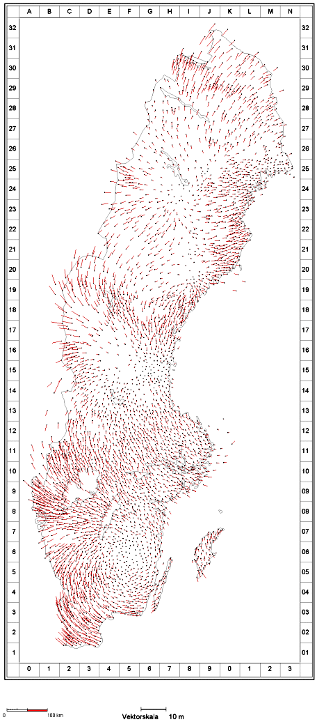
The absolute difference between point coordinates in RT 90 and RT 38 is generally of the order of 1–2 metres and reaches a maximum of about 5 metres.
Transformation between RT 38 and RT 90
There are no general transformation parameters between RT 38 and RT 90.
However, it is possible to perform transformation by interpolation in triangles, in a so-called model of residuals, between RT 38 and RT 90, with the Gtrans software.