

Contents of this page may be automatically translated, we take no responsibility for the accuracy of the translation. Feel free to contact our customer support centre if you have any questions.
There are thirteen different map projections referred to the three-dimensional reference system SWEREF 99. SWEREF 99 TM is used for applications at the national level, and there are twelve local projection zones to be used for applications at the local level.
SWEREF 99 was approved as an official realisation of ETRS89 at the EUREF meeting in 2000.
Map projection for SWEREF 99
Because neither three-dimensional coordinates nor latitude and longitude are particularly useful for practical applications and technical use, there is a need for a map projection referred to SWEREF 99.
The Gauss conformal (Transverse Mercator) projection, which has been used in Sweden for geodetic and cartographic purposes during the last century, satisfies requirements regarding conformality and is also well-suited from other standpoints. On the projection plane (the mapping plane) a two-dimensional Cartesian coordinate system is used, in which N (Northing) coordinates are measured northward from the Equator, which has an initial N value of 0 metres; and E (Easting) coordinates are measured from the central meridian, increasing eastwards.
National map projection – SWEREF 99 TM
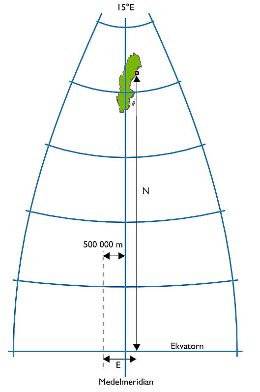 It is an advantage for many different applications at the national level if the whole Sweden can be mapped seamlessly, i.e. on one projection with position given in one coordinate system. A rigid application of, for example, UTM in Sweden would require a division into three zones.
The definition of a dedicated projection based on a meridian 15° E of Greenwich, with a scale factor of 0.9996, with the Equator as the origin for N coordinates and with E coordinates measured from the central meridian and increasing eastwards (the central meridian is assigned a value of 500 000 m to avoid negative values) will give consistency with UTM in the major part of the country.
Local projection zones
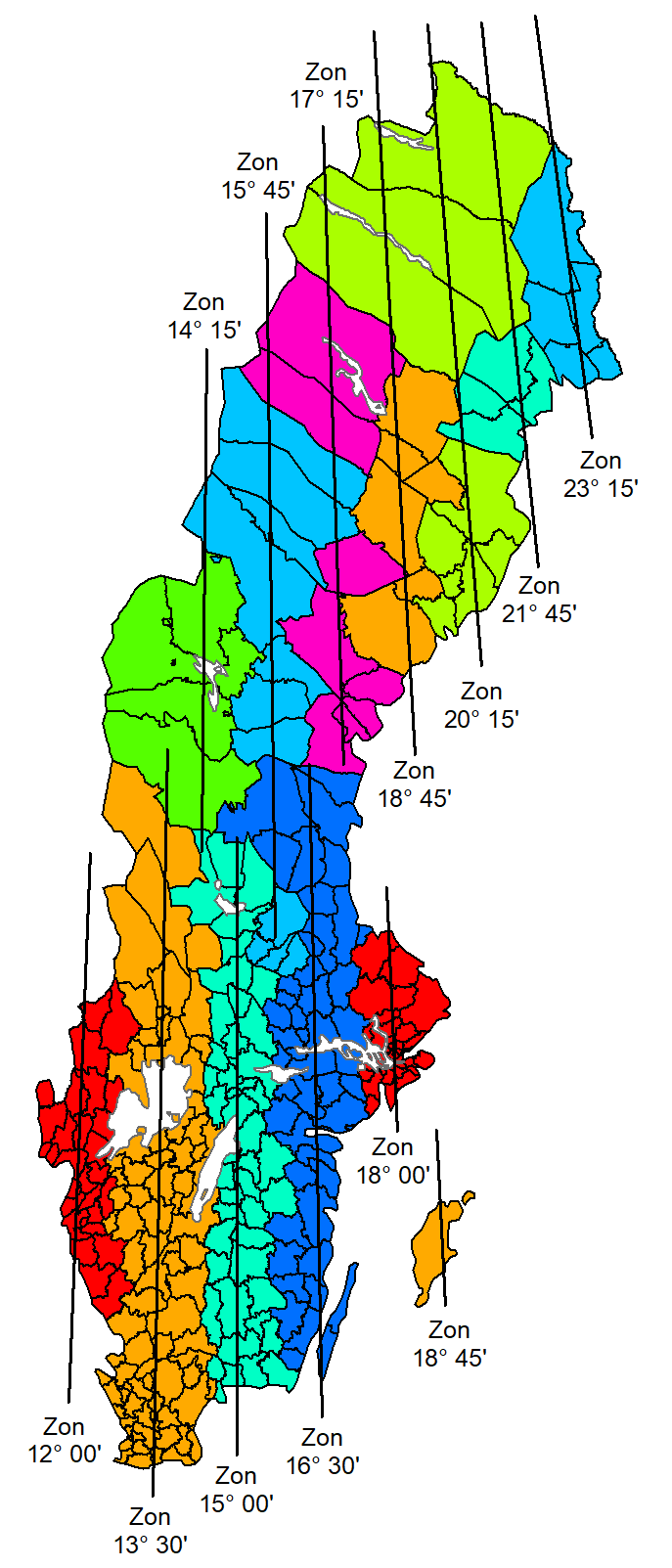
For applications on the local level, such as local authority technical activities, the projection must be designed in such a way that the inevitable deformations can, in most cases, be ignored. The most obvious deformation is variations in scale, which increase with distance from the central meridian. Scale changes can be kept at a reasonable level by limiting the area of validity for the projection both eastwards and westwards.
The division of Sweden into twelve zones with a scale factor equal to 1 (one) will reduce scale errors to 50 mm/km in the major part of the country.
Positions in the zones are given in a coordinate system that is in conformity with the national system: the Equator is the origin for N coordinates and E coordinates are measured from the central meridian and increase eastwards (the central meridian is assigned a value of 150 000 m to avoid negative values).
The local projection zones are named after the longitude value (given as degrees and minutes) of the respective central meridian, for example SWEREF 99 12 00 or SWEREF 99 18 45.
Uniformity
Already today, a lot of information is referred to SWEREF 99, although positions can be given in thirteen different plane coordinate systems.
Transition between these systems is done by re-projection of latitude and longitude from N and E coordinates whereby new N and E coordinates can be determined by projection in the appropriate zone. The N coordinates in all systems will be a 7-digit number in the integer part and the E coordinates will be a number with a maximum of 6 digits in the integer part.
The projection parameters for all projection zones in SWEREF 99
| Projection |
Central meridian, l0 |
Scale reduction factor, k0 | N reduction (m) | E addition (m) |
|---|---|---|---|---|
| SWEREF 99 TM | 15°00'E | 0,9996 | 0 | 500 000 |
| SWEREF 99 12 00 | 12°00'E | 1 | 0 | 150 000 |
| SWEREF 99 13 30 | 13°30'E | 1 | 0 | 150 000 |
| SWEREF 99 15 00 | 15°00'E | 1 | 0 | 150 000 |
| SWEREF 99 16 30 | 16°30'E | 1 | 0 | 150 000 |
| SWEREF 99 18 00 | 18°00'E | 1 | 0 | 150 000 |
| SWEREF 99 14 15 | 14°15'E | 1 | 0 | 150 000 |
| SWEREF 99 15 45 | 15°45'E | 1 | 0 | 150 000 |
| SWEREF 99 17 15 | 17°15'E | 1 | 0 | 150 000 |
| SWEREF 99 18 45 | 18°45'E | 1 | 0 | 150 000 |
| SWEREF 99 20 15 | 20°15'E | 1 | 0 | 150 000 |
| SWEREF 99 21 45 | 21°45'E | 1 | 0 | 150 000 |
| SWEREF 99 23 15 | 23°15'E | 1 | 0 | 150 000 |
Control points
Questions and answers
Yes, PROJ supports transformation of Swedish national coordinate and height systems. See Swedish transformations in PROJ (pdf, in Swedish, new window) for a brief introduction to the most common transformations.