

Contents of this page may be automatically translated, we take no responsibility for the accuracy of the translation. Feel free to contact our customer support centre if you have any questions.
Modern positioning systems – GPS, Glonass, Galileo and Beidou – are global and therefore require three-dimensional, globally adapted reference systems.
As satellite-based surveying techniques, such as GPS, began to be adopted on an increasing scale during the 1990's, the importance of three-dimensional reference systems also began to increase.
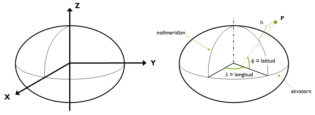
To state a position in a three-dimensional reference system
The fundament for all spatial information is the reference system. Normally, to state positions, we rely on a three-dimensional orthogonal (right-angled) coordinate system (X,Y,Z). This system is known as a Cartesian coordinate system. It is possible to convert these positions into geodetic coordinates, namely latitude and longitude. These, along with height above the ellipsoid, collectively define a location's three-dimensional position in a more intuitively understandable way.
Global reference systems
Global three-dimensional reference systems must be able to accommodate changes in the Earth's shape, such as those caused by plate tectonics. This necessity has made epoch management important, which is the specification of the exact time at which a location's position is determined. Such reference systems, where a point's coordinates changes over time, are referred to as dynamic.
Global reference systems are recalculated periodically, and these recalculations are known as different realisations of the system. In English terminology, a distinction is made between reference system and reference frame. A reference system refers to the theoretical definition of the system, whereas a reference frame refers to the practical implementation, meaning the established positions of points in a reference network. In Swedish, this distinction is not made, but both concepts are simply referred to as "referenssystem."
| Reference system |
Plate techtonic epoch | Internal epoch | Producer | Comments |
|---|---|---|---|---|
| ITRFyyyy | Dynamic | Same as the plate tectonic epoch | IERS (International Earth Rotation Service) | For calculation of satellite orbits, precise GNSS-calculations, scientific studies. A small number of SWEPOS stations are included. |
| WGS 84 | Dynamic | Same as the plate tectonic epoch | NGA (National Geospatial-Intelligence Agency, USA) | The measurement method is exclusively GPS. |
| ETRS89 realisations | 1989.0 | Varying | EUREF / olika europeiska kartmyndigheter | |
| SWEREF 99 | 1989.0 | 1999.5 | Lantmäteriet | National reference system. Coincides with similar solutions at centimetre level. |
Reference systems for GNSS
The various satellite navigation systems, known as GNSS (Global Navigation Satellite Systems), utilise different three-dimensional global reference systems. Today, all such reference systems are connected to the ITRS.
| Satellite system |
Reference system |
Ellipsoid | Comments |
|---|---|---|---|
| GPS | WGS 84 | WGS 84 | World Geodetic System. The ellipsoid differs by 0.1 mm in the semi-minor axis from the GRS 80 ellipsoid. |
| Glonass | PZ‑90.11 | PZ‑90 | Parametry Zemli (Earth Parameters). The ellipsoid differs by appr. 1 m in both the semi-major and semi-minor axis from the GRS 80 ellipsoid. |
| Galileo | GTRF | GRS 80 | Galileo Terrestrial Reference Frame |
| Beidou | CGCS 2000 | GRS 80 | China Geodetic Coordinate System |
Questions and answers
Latitude and longitude can be given either as decimal degrees; or degrees and decimal minutes (actually arc minutes); or degrees, minutes and decimal seconds (actually arc seconds). Hence there are three ways to enter one and the same position. See examples of a latitude below:
- Decimal degrees: 60.75350° N
- Degrees, decimal minutes: 60°45,210'N
- Degrees, minutes, decimal seconds: 60°45'12.6"N
There is an Excel sheet for conversion between the different formats (xlsx, new window).
The difference between latitude and longitude in RT 90 and globally adapted reference systems (pdf, in Swedish, new window) (SWEREF 99, WGS 84 and others) is about 100–300 meters in Sweden.
In order for a position expressed as latitude and longitude to be unambiguous, one must specify which reference system is used.