

Contents of this page may be automatically translated, we take no responsibility for the accuracy of the translation. Feel free to contact our customer support centre if you have any questions.
Satellite positioning includes the methods and techniques used to determine the location of a point and to navigate, by measuring distances from several satellites.
GNSS, satellite positioning and GNSS measurements
The satellite systems used for this purpose go under the collective name GNSS, Global Navigation Satellite Systems. GPS is the most well-known system. Satellite positioning and GNSS measurement are often used as synonymous terms.
What is required to do satellite positioning?
Satellite positioning requires a clear line of sight and a so-called GNSS receiver, which is a special equipment receiving radio signals from one or more GNSS. GNSS receivers are available in many different designs and price ranges.
Simple and cheap receivers are used, for example, in car navigation systems and smart phones, while more advanced receivers are used for house building, infrastructure projects and other production applications with high precision requirements.
To improve precision and reliability, GNSS is often combined with ground-based support systems, such as Swepos.
How does it work?
The basic principle of GNSS positioning
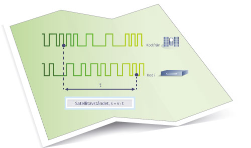
The basic principle for all GNSS receivers is the same. The coded radio signals transmitted from the satellites are compared with identical signals generated in the GNSS receiver itself.
An advanced measuring tape
The measured difference between the received and generated signals can be translated into a time difference that provides information about how long it took the signal to reach the GNSS receiver. Since both time and speed (that is, the speed of light) are known, the distance between satellite and GNSS receiver can be calculated. Consequently, the technology can be seen as a kind of advanced measuring tape!
GNSS satellite locations are known in a global reference system
The GNSS satellites are in orbit around the Earth. Their positions are known in a global geodetic reference system and are known, with some uncertainty, at all times. By measuring the distance to several satellites, the position of the GNSS receiver can therefore be determined in the same reference system.
Information about the positions of the GNSS satellites is transmitted with the satellites' so-called navigation message together with status and time indications.
Read more about the most common methods for GNSS measurement.
Interactive services
Here you will find GNSS-related services. You can, among other things, transform coordinates.