

Contents of this page may be automatically translated, we take no responsibility for the accuracy of the translation. Feel free to contact our customer support centre if you have any questions.
When performing the third national triangulation in 1967–1982, it was decided to divide Sweden into twelve regions in order to quickly give the users access to the new coordinates.
Initial results from the third national triangulation programme
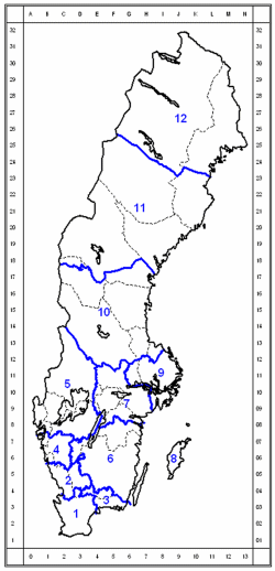
| Region | Name |
|---|---|
| 01 | Skåne |
| 02 | Halland |
| 03 | Karlshamn |
| 04 | Göteborg |
| 05 | Vänern |
| 06 | Småland |
| 07 | Örebro |
| 08 | Gotland |
| 09 | Stockholm |
| 10 | Gävle-Dala |
| 11 | Umeå |
| 12 | Luleå |
As the triangulation progressed from south to north, coordinates in the corresponding regional system, RT R01 – RT R12, were computed. Each such system was assigned a fixed point with coordinates in RT 38 (or in one of the neighbouring region systems). The calculations were made on Bessel's ellipsoid in 1841 with geoid heights in RAK 70.
Each region was initially given both a name and a number. Today, it is mainly the designation RT Rxx that is used, where xx refers to the region number.
The difference from RT 90
The absolute difference between coordinates in RT 90 and the regional systems is maximum 3–4 meters radially, but usually about 1 meter or less.
Between the regional systems and RT 90, so-called Helmert transformations are defined. In addition, a special method for interpolating the residual errors was developed, to obtain a transformation that was error-free in the control points used for the Helmert transformations. Read about the Gtrans software.
Map projection
Plane coordinates of the regional systems are given in Gauss-Krüger's projection with local central meridians in the same way as for RT 90 and RT 38.