

Contents of this page may be automatically translated, we take no responsibility for the accuracy of the translation. Feel free to contact our customer support centre if you have any questions.
The satellite database Saccess contains free satellite images of Sweden from the 1970s onwards. The product name in Swedish is Satellitbilder.
About this product
The satellite database is a tool for studying the landscape changes that have taken place over almost five decades - for the benefit of, for example, agriculture and forestry, environmental analyzes and planning, but also for the interested public.
The nationwide datasets are of optical multispectral data from satellites with a geometric resolution of 10 - 30 meters. The exception is the MSS data from the 1970s, which has a resolution of 80 meters.
The information in Saccess is free of charge and available to all users on equal terms, regardless of whether they are authorities, companies or individuals.
Applications
The database contains satellite data that is adapted to different types of users, eg:
- raw data for the expert
- map-correct images for the accustomed GIS user
- cloudless mosaics for those who want to visualize a larger area than what is covered by a single image.
The mosaics are composed of map-correct images and are presented partly as infrared vegetation images and partly in natural colors.
Invaluable analytical basis
The historical database with images from the 1970s onwards provides unique opportunities to, for example, study changes in the environment and the effects of climate change and more. Annual updates of the database provide the opportunity for frequent follow-ups.
What does the information mean?
Each scene stored in Saccess contains a wealth of information about that particular scene. This information, metadata, contains information about the conditions that prevailed when the scene was recorded. It can be anything from the date of registration, to the angles of the sun and the position of the satellite in relation to the earth's surface. The information is necessary to, for example, be able to correct data and make them map-correct. There is also information about which file formats the data is stored in, and which spectral wavelength bands the satellite's sensors comprise.
Each scene also includes a small overview image that can provide fast and clear visual information about, for example, any cloud presence in the scene.
Since metadata is quite extensive, there is no room to describe all records, but here are some key concepts:
- Imaging date
Specifies the date when the scene was taken. - Imaging Time
Specifies the time, in GMT, when the scene was taken. - Mission
Indicates the name of the current satellite. - Instrument
Displays the designation of the sensor used. - Grid Reference
A way to divide the earth's surface into a grid in order to know approximately where the scene is located. - Copyright
Shows how copyright shall be stated when any data is published. Special rules apply and you are always asked to contact our support before publication (Contact us in the menu).
Reference document
Landsat
- GAEL calibration proceeding (pdf)
- L7 IAS 070998 (pdf)
- Landsat 7 Image Assessment System / Geometric Algorithm Theoretical Basis Document (pdf)
- LandsatEtmCeos 3.1 (pdf)
- Landsat5 and Landsat7 Geometric Corrections updates (pdf)
SPOT
IRS
Dataset/content
What do the datasets contain?
Saccess contains optical satellite data with historical datasets from the 1970s, 1980s, turn of the millennium and 2005 and annual nationwide datasets from the year 2007.
Data are received during the vegetation period and period, and have a geometric resolution of 10-30 meters. The exception is data from the 1970s that have a resolution of 80 meters. Optical data with a resolution of 10-30 meters is the type of satellite data that has the widest operational use in Sweden today.
System-corrected data
System-corrected data, is data that is as close to the raw product as possible. Corrections have only been made for the satellite system's internal parameters.
If you want to read more about how these corrections were made, you can find documents with detailed specifications from the various satellite operators here.
Orthocorrected data
Most satellite image applications require The accuracy of the information contained in the images is often used in conjunction with other geographical information. It is therefore essential that the image maintains the same standard of accuracy as maps and other data.
To achieve changes over time, to achieve this accuracy, the data recorded by the satellites are corrected to take into account ground curvature, elevation differences and other parameters that shift the image information, and a map-correct image is created.
Quality controls
To ensure that the scenes in Saccess meet the set quality requirements, a number of checks are performed:
- Checking metadata, ie that there are values in metad the atafile and that the corner coordinates are correct.
- Overview check for all scenes. Each scene is checked against aerial photography. If there are deviations at any point that are more than one pixel, the scene is rejected. Any resampling edges, drop-outs or other deviations in image data are also checked and noted.
- Detailed control for a selection of scenes. Approximately 10 scenes per dataset are selected and control points are taken in satellite data and aerial photo. Deviations at each point and RMS are calculated. This check is done for the images approved in the overview check.
Mosaics
The mosaics consist of several images that are put together to cover larger areas and can be delivered both in form of infrared images that show different vegetation types and images with natural colors that are easier to interpret for ordinary people.
Satellite images by year
Sweden 2017–
From and with 2017, each annual coverage consists only of data from Sentinel 2, which is part of the European Earth observation program Copernicus. Sentinel 2 registers data in 13 spectral bands and has a geometric resolution of 10 x 10 meters.
All Sentinel data are retrieved from ESA at level L1C, which means that they are already to some extent geometrically corrected. For this reason, there is also no system-corrected data available for Sentinel 2.
Before entering data into the Saccess system, the geometry is further improved using a national elevation model and control points from aerial orthophotos. Data is transformed into a national projection and given shorter names to make it easier to use in the most common software.
The following band combinations are used for the Sentinel products that can be ordered from Saccess:
Ortho-corrected products: Can be taken out as either a 3-band product with bands B4, B3, B2 or a product containing all spectral bands.
Color mosaic: Band B4, B3, B2
IR mosaic : Bands B8, B11, B4
For public use of Sentinel data from Saccess, the data source is stated as follows: Contains modified Copernicus Sentinel data
Sweden 2016
Sentinel 2
For the most part, the 2016 coverage consists of data from Sentinel 2, which is part of the European Earth observation program Copernicus. Sentinel 2 registers data in 13 spectral bands and has a geometric resolution of 10 x 10 meters.
All Sentinel data are retrieved from ESA at level L1C, which means that they are already to some extent geometrically corrected. For this reason, there is also no system-corrected data available for Sentinel 2.
Before entering data into the Saccess system, the geometry is further improved using a national elevation model and control points from aerial orthophotos. Data is transformed into a national projection and given shorter names to be easier to use in the most common software.
The following band combinations are used for the Sentinel products that can be ordered from Saccess:
- Orthocorrected products: Can be taken out as either a 3-band product with bands B4, B3, B2 or a product containing all spectral bands.
- Color mosaic: Band B4, B3, B2
- IR mosaic: Band B8, B11, B4
For public use of Sentinel data from Saccess, the data source is stated as follows: Contains modified Copernicus Sentinel data 2016, Processing Metria AB .
IRS-P6
© ANTRIX, SI, Euromap Neustrelitz.
Sweden 2015
IRS-P6
© ANTRIX, SI, Euromap Neustrelitz.
Landsat 8
USGS / NASA Landsat, Bearbetning Metria AB
Sverige 2014
IRS-P6
© ANTRIX, SI, Euromap Neustrelitz.
Landsat 8
USGS / NASA Landsat, Bearbetning Metria AB
Spot 5
CNES © Distribution Airbus DS 2014.
Sweden 2013
Landsat 8
USGS / NASA Landsat, Bearbetning Metria AB
Spot 5
CNES © Distribution SpotImage 2013.
Sweden 2012
Spot 4, Spot 5
CNES © Distribution SpotImage 2012 .
IRS-P6
© ANTRIX, SI, Euromap Neustrelitz.
Sverige 2011
Spot 4
Spot 5
Copyright for SPOT data from Sweden 2011: CNES © Distribution SpotImage 2011.
Landsat TM
Copyright for Landsat data from Sweden 2011: Landsat Imagery, © ESA / Eurimage, 2011.
Sverige 2010
Spot 4
Spot 5
Copyri ght for SPOT data from Sweden 2010: CNES © Distribution SpotImage 2010.
IRS-P6
Copyright for IRS-P6 data from Sweden 2010: © ANTRIX, SI, Euromap Neustrelitz .
Sweden 2009
Spot 4
Spot 5
Copyright for SPOT data from Sweden 2009: CNES © Distribution SpotImage 2009
IRS-P6
Copyright for IRS-P6 data from Sweden 2009: © ANTRIX, SI, Euromap Neustrelitz
Landsat TM
Copyright for Landsat data from Sweden 2009: Landsat Imagery, © ESA / Eurimage, 2009.
Sweden 2008
Spot 4
Spot 5
Copyright for SPOT data from Sweden 2008: CNES © Distribution SpotImage 2008
IRS-P6
Copyright for IRS-P6 data from Sweden 2008: © ANTRIX, SI, Euromap Neustrelitz
Landsat TM
Copyright for Landsat data from Sweden 2008: Landsat Imagery, © ESA / Eurimage, 2008.
Sweden 2007
Spot 4
Spot 5
Copyright for SPOT data from Sweden 2007: CNES © Distribution SpotImage 2007
IRS-P6
IRS-P6 is the tenth satellite in the Indian space agency ISRO's satellite program. IRS-P6 registers multispectral data in four spectral bands with 23.5 meters resolution.
Copyright for IRS-P6 data from Sweden 2007: © ANTRIX, SI, Euromap Neustrelitz < / p>
Landsat TM
Copyright for Landsat data from Sweden 2007: Landsat Imagery, © ESA / Eurimage, 2007.
Sweden 2005
Spot 4
The first SPOT satellite started sending images of the earth's surface in 1986. It was later followed by SPOT 2 (1990) and SPOT 3 ( 1993). The first three satellites in the SPOT program delivered data in 20 meters resolution in three spectral bands, green, red and near infrared, as well as black / white data in 10 meters resolution. In addition to these bands, SPOT 4 also contains a fourth spectral band, the middle infrared.
Spot 5
In early May 2002, the Earth observation satellite SPOT 5 was placed in its orbit around the Earth . Compared to its predecessors, SPOT 5 offers improved mapping capabilities through color data with 10 meters resolution. (20 meters for the middle infrared band).
Copyright for SPOT data from Sweden 2005: CNES © Distribution SpotImage, 2005
Landsat TM
Copyright for Landsat data from Sweden 2005: Landsat Imagery, © ESA / Eurimage, 2005
Sweden - turn of the millennium
Landsat TM
Landsat ETM +
Landsat 7 with the instrument ETM + was launched on April 15, 1999. What mainly distinguishes ETM + from the previous TM instruments is a black / white band with a resolution of 15 meters.
Copyright för Sverige Millennieskifte: Landsat Imagery, © ESA / Eurimage, 1997-2002.
Sweden 1980s
Landsat TM
Until the mid-1980s, Landsat was the only commercial satellite program. Landsat TM is a sensor on Landsat 4 and 5 that has been in use since July 1982. Data are recorded in seven spectral bands with a geometric resolution of 30 meters, and a thermal band that registers temperatures on the earth's surface. The scene size is the same as for Landsat MSS, approximately 180 x 180 kilometers.
Copyright for Landsat data from Sweden 1980s: Landsat Imagery, © ESA / Eurimage, 1986-1990.
Spot 1-3
The first SPOT satellite began sending down images of the Earth's surface in 1986. It was later followed by SPOT 2 (1990) and SPOT 3 ( 1993). The first three satellites in the SPOT program delivered data in 20 meters resolution in three spectral bands, green, red and near infrared, as well as black / white data in 10 meters resolution.
Copyright for SPOT data from Sweden 1980s: CNES © Distribution SpotImage, 1990.
Sweden 1970s
Landed MSS
Landed 1 with the MSS sensor was the first commercial satellite. It was launched as early as July 1972. MSS was also present on the subsequent Landsat 2 through 5 and recorded images of the earth's surface until October 1992.
Landsat MSS recorded data in four spectral bands with a geometric resolution of about 80 meters and each stage covered an area of about 170 x 185 kilometers. The MSS data in Saccess has been restored and adapted for further processing.
Copyright for Sweden 1970s: Landsat Imagery © ESA / Eurimage, 1972-1981
Demo data
Full-resolution product examples
The map image used to search and select satellite data shows only low-resolution data. The products ordered from the system, on the other hand, are fully resolved, in most cases between 10 - 30 meters per pixel.
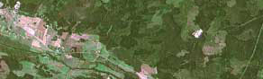
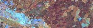
Here you can download fully resolved product examples. The two images are partly a mosaic in infrared colors over Tyresta from the 1980s, and partly a mosaic in natural colors over the same area from 2007. In the latter image you can clearly see the area around Stensjön that was affected by the fire in 1999.
Tyresta nationalpark 1980s, mosaic infrared colors (zip, 5Mb)
Tyresta National Park 2007, mosaic natural colors (zip, 5Mb)
Order product
Everyone in Saccess can view satellite data with low-resolution quality.
To order full-resolution mosaics and scenes, you need to register as a user.
Questions and answers
Lantmäteriet has received a special government grant to cover the costs of establishing Saccess and for the annual data collections. This allows us to provide free data to Saccess users.
The license gives the user the right to use the products as they are and/or process them for personal and/or internal use. Regarding further processing and dissemination outside one's own organization, there are restrictions, read more in the agreement (pdf, new window).
For those of you who are already a registered user, it generally only takes a couple of minutes before you receive a confirmation of the email address you provided. The confirmation contains a link to a download page.
On that page you can follow the production process, and when the product is fully generated, click on the download icon that appears when the product is finished being processed, to save the products on your computer.
How long the processing takes depends on how much data you have ordered, and how many jobs are running at the same time, but normally the product/products should be available within about fifteen minutes.
Contact
To get answers to what applies in your particular case, please contact us via e-mail: saccess@lm.se
Opening hours
Monday - Friday 9.00 - 16.00