

Contents of this page may be automatically translated, we take no responsibility for the accuracy of the translation. Feel free to contact our customer support centre if you have any questions.
RTK, Real-Time Kinematic, is another name for real-time relative carrier phase measurement and the applied real-time method that usually has the lowest measurement uncertainty. RTK measurement requires GNSS receivers that are capable of carrier phase measurement on multiple frequencies and some kind of data link for the transmission of RTK corrections between the receivers in real time, such as radio communication or mobile Internet.
What is RTK measurement?
RTK provides the possibility of a measurement uncertainty in the order of one to a few centimetres, provided that the receiver is initialised correctly, i.e. that the ambiguity are fixed to the correct integer (so-called fix solution). Initialisation typically takes between about ten seconds and one minute, depending on local conditions. As the distance between the reference station and the rover increases, initialisation will become more difficult, and the measurement uncertainty will increase. The same applies to rapid and large changes in the ionosphere or troposphere.
The local measurement environment and the user's implementation also affect the measurement uncertainty that can be achieved in RTK measurement. Advice and guidelines (in Swedish) for RTK users can be found in HMK – GNSS-based detail surveying.
Single-station RTK with your own reference station
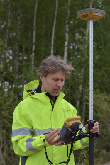
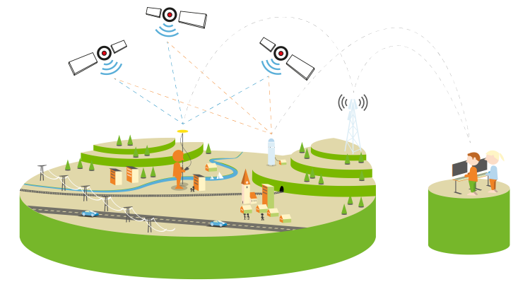
Traditional RTK measurement using a temporary reference station is usually called single-station RTK. In the case of single-station RTK, you set up a reference receiver over a point with a known position and you do measurements with another receiver (called rover) on the points whose positions you want to determine. Using relative positioning, the rover combines its own GNSS observations with those of the reference station, reducing the impact of the sources of error, and obtaining a position. However, this requires that the reference station and the rover observe the same set of GNSS satellites at the same time, and that the data link can transmit the reference station's position and observations in real time to the rover.
Network RTK with a network of CORS
Network RTK is an evolution of the single-station RTK concept, with several Continuously Operating Reference Stations (CORS) working together to optimise the handling of error sources and give you access to seamless RTK measurement of comparable quality over a larger coverage area. In this concept, the CORS continuously send GNSS observations to a control centre of the network, which collects instantaneous information about the sources of error caused by signal disturbances in the atmosphere, as well as clock and orbital faults. A special network RTK software can be used to manage the entire chain of
- receiving incoming data flows from the stations
- generating RTK corrections based on these flows
- finally sending tailored corrections to you when you connecting to the network RTK service.
The dominant network RTK technology to date is called VRS or Virtual Reference Station, which means that the control centre "simulates" a reference station in the vicinity of your rover. Data from the control centre to your rover is transmitted in a standardised relative positioning format, RTCM. In principle, this solution means that you can use the same RTK equipment as with single-station RTK. However, VRS technology requires two-way communication for you to be able to report your approximate position to the control centre. The network RTK software then tailors simulated reference station data for your reported position.
Pros and cons of network RTK
Network RTK has both advantages and disadvantages compared to single-station RTK.
Some advantages of network RTK:
- The method only requires you as a user to have only one RTK receiver. You do not have to establish you own reference station, nor do you need to ensure the quality of these yourself.
- Allows you to achieve more consistent quality in a larger coverage area, unlike single-station RTK where the measurement uncertainty increases significantly with the distance to the reference station.
- Measurements are made directly a uniform and modern reference system adapted for GNSS measurement; in Sweden SWEREF 99.
Some disadvantages of network RTK:
- The method requires functioning mobile internet, i.e. two-way communication, between the service provider and you as a user.
- Lack of traceability, as the you do not have access to complete information about the calculation method.
Use of network RTK in Sweden
Lantmäteriet has run SWEPOS Network RTK service since 2004. In addition to SWEPOS Network RTK service, there are also a number of other network RTK services from Lantmäteriet's partners, that are based on data from the same CORS network, namely the stations included in the SWEPOS network (new window).
When measuring with network RTK under normal conditions, a measurement uncertainty at the centimetre level is possible to achieve. The closer you are to a reference station and the denser the CORS network is, the better the technology can model the sources of error thereby reduce the measurement uncertainty of your measured position. The SWEPOS network has about 35 km between the reference stations in large parts of Sweden. In the mountains in northwest, the distance between the reference stations can be up to 70 km in individual places, and in the metropolitan regions and in some areas with large infrastructure projects going on, the network is densified to about 10 km between the CORS.
Estimated measurement uncertainty values for different distances to reference stations as well as advice on measurement methodology for carrying out network RTK measurement (in Swedish) can be found in HMK – GNSS-based detail surveying.
Preparing for mass-market applications
The RTK technology is mainly used for professional practice with advanced GNSS receivers in geodetic surveying, machine control and agricultural applications and has about 10–15 000 users in Sweden. However, the technology is evolving and pilot projects are underway to study the use of RTK rechnology with simpler GNSS receivers in e.g. mobile phones and for positioning of autonomous vehicles and vessels. Such a future mass market with hundreds of thousands of users, requires different techniques for transferring corrections data, than the virtual reference station with tailored corrections for each user used today.
Lantmäteriet participates, together with other parthers in the industry, in a number of development projects to prepare the such mass market applications for accurate GNSS positioing in various ways. Examples of projects are: