

Contents of this page may be automatically translated, we take no responsibility for the accuracy of the translation. Feel free to contact our customer support centre if you have any questions.
This page is aimed at municipalities that have DRC agreements and work with quality development of national register maps regarding property division, rights and community facilities.
The municipality makes updates in the national register map through continuous deliveries of quality improvements. Feedback from Lantmäteriet to the municipality can take place on a daily basis according to the Register Map - Lantmäteriet format from the DRK site. The agreement includes quality improvements in digital form regarding property division, rights and community facilities.
With the standard agreement as a template, DRK agreements can be signed between Lantmäteriet and all municipalities which has a state surveying authority (SLM), including the municipalities that carry out administrative preparations (KFF).
DRK site
The DRK site gives you who use Registerkarte-GML as a format, daily feedback of the register map. Authorization and instructions for the DRK site can be ordered via Order form (pdf, new window).
Access to Archive Search and spatial data services
DRK agreement gives the municipality the right to use the following of Lantmäteriet 's services free of charge:
|
ArkivSök |
Lantmäteriet 's digital archive Arken, containing administrative acts, historical maps, etc. |
|
Akt Direkt |
Direct access service to Ark via the Internet. Can be integrated into external users' own operating systems. |
|
Property classification Display |
Service that presents property information from Lantmäteriet 's basic data warehouse. |
| Altitude model Display |
Service that shows raster images that visualize the shape of the terrain in two variants, a slope image and a shadow image. The images are based on a terrain model with altitude data from laser scanning of the ground surface. |
For more information regarding the services, see Lantmäteriet 's website.
Municipalities that have signed user agreements for Geodata Collaboration are entitled to these services according to current terms of use, for the entire municipality's operations. To order these services, contact geodatasupport@lm.se.
Municipalities that are not part of Geodatasamverkan get access to the services by fill in the intended the order form (docx). In addition, for the ArchiveSearch and geodata service Act Direct an Akt purpose test (docx) to be attached. Everything is sent to geodatasupport@lm.se.
For municipalities that is not part of the Geodata collaboration, the services may only be used for the activities that are linked to the DRC agreement.
Training opportunities
Lantmäteriet offers a three-step training package for those who belong to a municipality with a valid DRC agreement and who are to measure and deliver quality improvements. The municipality is responsible for the delivery of quality improvements and for them to maintain the quality required for storage in the national register map, this training is available.
Step 1: Web training to be carried out by everyone who manages deliveries of quality improvements in the property classification linked to the DRC agreement.
Step 2: Web training for the people who produce the basis for quality improvements in the property classification.
Note: Person who possess knowledge for field measurement of quality improvements, e.g. in administrative activities, such as SLM, KLM or KFF municipality, do not need to go step 2.
Step 3: Web training that leads to the certification of a responsible person in the municipality to DRK deliveries to Lantmäteriet shall maintain the quality required for storage in the national register map.
Note: For diploma, step 2 is not required if the person already has knowledge for field measurement of quality improvements .
Lantmäteriet does not charge a participation fee for the educations.
Regarding registration, connection for web educations and the next education opportunity, see Lantmäteriet 's website.
Manual
Handbook concerning the DRC agreement (in Swedish, pdf, new window).
Delivery, instructions and support
- Deliveries of property division and boundary points, less than 5 MB, are sent by e-mail to: ajourhallning-DRK@lm.se
- Deliveries larger than 5 Mb are delivered to Lantmäteriet 's File Condition (FTP server, new window)
It does not matter how the files are named, the main thing is that it appears from the email subject line which county and municipality the delivery applies. (eg Dalarna s län, Mora)
In the delivery, a filled delivery form (pdf, new window) attached.
Lantmäteriet 's special group for quality improvements (KUF) takes care of the delivery. Confirmation is sent when the register map is updated.
Other questions are asked via the function mailbox: ajourhallning-DRK@lm.se
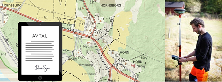
Sign DRK agreements
To sign an agreement, contact your Regional Geodata Coordinator (RGS). Below is a template for an agreement and associated appendix as well as contact information for your RGS.
- Normal agreement DRK (pdf, new window)
- Appendix to the DRC agreement (pdf, new window)
Municipalities that have signed DRK agreements
In 2021, 27 were signed. new DRC agreements with municipalities around Sweden. It is great that in this way, through collaboration, we can work to have as good a foundation as possible to stand on before the continued digitization of the community building process. The contract work will continue in 2022.
The municipalities that have signed cooperation agreements regarding quality development of the national register map (DRK) are reported here
List of municipalities that have signed DRC agreements (pdf, new window)
Map/overview (pdf, new window)
Collaboration project - an opportunity within the DRC agreement
Within Lantmäteriet, we carry out many years of work aimed at improving the Property Register, including the quality of the register map.
The DRC agreements include the possibility for the municipality to synchronize property and rights layer with Lantmäteriet 's register map. After a synchronization has been completed, it is possible to start a collaboration project.
Collaboration takes place by both parties assisting with background material, knowledge and time. This is done in equal parts by the parties involved. An agreement is written where the efforts that are to be included in the collaboration are defined.
If a DRC agreement has been signed and you are interested in being part of a collaboration project, you must contact the Regional Geodata Coordinator for your county.
Collaborative projects begin with the municipality prioritizing areas of poor quality. There may be areas with low quality where existing buildings are to be connected to VA, but also other areas where the municipality experiences difficulties with the quality of the property subdivision outside the detailed planning area.
Telephone and address list with zoning (pdf) for all regional spatial data coordinators.