

Contents of this page may be automatically translated, we take no responsibility for the accuracy of the translation. Feel free to contact our customer support centre if you have any questions.
The service delivers a high-performance background map for many simultaneous calls. The product is part of Lantmäteriet’s open data and can be accessed without a licence fee and with simplified terms of use. The product name in Swedish is Topografisk webbkarta Visning, översiktlig.
About this product
Instead of creating a new picture for each call, the service returns small pre-generated images in set scale levels. The map contains a selection of Lantmäteriet’s products, ranging from the Map of Sweden 1:5 million to the Topography 50.
The service contains one layer with topographic map information that is presented clearly in full colour and one layer that presents the topographic map information in toned-down greyscale.
The map information is displayed with a harmonised cartography between the scales. The information in the service is adapted to be displayed in scales less than 1:30 236. When zooming in to scales larger than 1:30 236, no changes to the contents occur apart from a simple enlargement of the information.
Maintenance and update frequency
The information is updated in different intervals depending on the type of information and scale level. A simplified description of the topicality is that:
- The information in scale areas up to 1:60 000 is updated every week.
- The information in scale areas over 1:60 000 is updated every month.
Availability
Our geodata services are normally available 24/7 and we provide support during working hours. Read more about availability to geodata services.
Presentation of the information layers
Topographic web map
The layer contains topographic map information such as administrative divisions, buildings, facilities, regulations, roads, railways, mountain information, electricity transmission lines, ground surfaces, water surfaces, height contours and terrain shading, place names, informational text, and addresses.
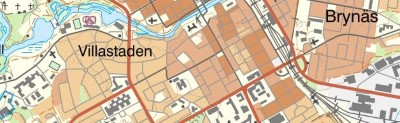
Example image in scale 1:30236.
Topographic web map, toned-down
The layer contains the topographical map information presented in a toned-down greyscale.
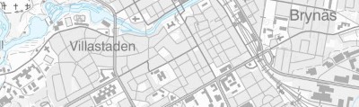
Example image in scale 1:30236, toned-down.
Documentation
Different versions of the services can overlap, so pay attention to which version you use. Version history describes the changes that occurred with each update.
| Version | Date | Changes compared with previous version |
|---|---|---|
|
Version 1.0.3 |
Updated 2023-02-01 |
|
|
Version 1.0.3 |
Updated 2022-09-01 |
|
|
Version 1.0.3 |
Updated 2021-10-25 |
|
|
Version 1.0.2 |
Updated 2021-10-01 |
|
|
Version 1.0.2 |
Updated 2019-03-27 |
|
|
Version 1.0.2 |
Updated 2018-06-29 |
|
|
Version 1.0.1 |
Updated 2017-09-20 |
|
|
Version 1.0.1 |
Updated 2017-01-17 |
|
|
Version 1.0.1 |
Available in production environment 2016-01-01. This version change has incorrectly been dubbed v 1.1 in a news article. |
|
|
Version 1.0 |
Discontinued 2016-06-01 |
Technical framework and standard for view services
Our map and image view services are based on the standardized call interfaces Web Map Service (WMS) and Web Map Tile Service (WMTS) developed by The Open Geospatial Consortium (OGC). WMS is also an ISO standard (ISO 19128).
The Open Geospatial Consortium website (new window)
The services are of the nature 'question-answer', where the consumer (user's system) sends a service call over the Internet and receives a map image in a standard image format or in a vector format for certain types of services.
The characteristics of the map image are defined by the call parameters, such as information type, geographical spread, reference system, image format and image size.
There are many client applications for display services or components for integration into own system available. In addition to commercial products, there are a number of established products based on open source code, such as QGIS.
At OSGeo, The Open Source Geospatial Foundation you can read more about software in the field of geodata that are based on open source code.
Do you want deeper technical information about our geodata products you can read the product documentation.
Our geodata products with API:s require that you have an application or software capable of managing the services. To view real property information or maps directly in your browser, you can use Lantmäteriet's e-services.
Download product
Retrieve open data
To retrieve Lantmäteriet’s open data you need to have a user account. You use this account every time you download data or connect to a service.
The user account gives us the possibility to monitor the use of our open geodata as well as to provide feedback to you in case of any changes.
Forgot your username or password?
The license and what it means
Our open spatial data is available under the Open Data License; Creative Commons, CC0. The license means that you may use, distribute, redo, modify and build on Lantmäteriet's open data.
This also applies in commercial contexts without any restrictions. Feel free to list Lantmäteriet as the source when you disseminate our open data, but this is not a requirement.
Open source
Client using Topographic Sitemap Display, overview for simple downloads of map images is available as open source code.
It can be used as a code example for how to use Topographic Sitemap Display, overview, as a basis for developing your own applications or submitting suggestions for changes directly in the code.
The source code is made available under the license Apache version 2.0. This basically means that it can be used in own or open applications, but that there are restrictions on using the brand.
Choose one of the following options: