

Contents of this page may be automatically translated, we take no responsibility for the accuracy of the translation. Feel free to contact our customer support centre if you have any questions.
This service provides access to a topographical web map that is adapted for display on a screen. The map information is displayed with a harmonised cartography between the scales. The product name in Swedish is Topografisk webbkarta Visning.
About this product
The service contains one layer with topographic map information that is presented clearly in full colour and one layer that presents the topographic map information in toned-down greyscale.
Maintenance and update frequency
The information is updated with different intervals depending on the type of information and scale level. A simplified description of the topicality of the information is that:
- The information in scale areas up to 1:15 000 is updated every 24 hours.
- The information in scale areas1:15 000 – 1:60 000 is updated every week.
- The information in scale areas over 1:60 000 is updated every month.
Availability
Our geodata services are normally available 24/7 and we provide support during working hours.
Read more about availability to geodata services.
Presentation of the information
Topographic web map
The layer contains topographic map information such as administrative division, buildings, facilities, regulations, roads, railways, mountain information, power lines, land surfaces, water surfaces, elevation curves and terrain shading, place names, information text and address numbers.
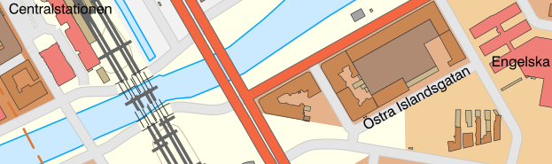
Example image in scale 1: 5 000.
Topographic web map, toned-down
The layer contains the topographical map information presented in a toned-down greyscale.
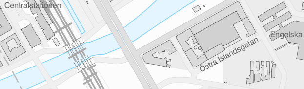
Example image in scale 1: 5 000, toned-down.
Documentation
Different versions of the services can overlap, so pay attention to which version you use. Version history describes the changes that occurred with each update.
| Version | Date | Changes compared with previous version |
|---|---|---|
| Version 1.0.4 | Updated 2023-02-01 |
|
| Version 1.0.4 | Updated 2022-09-01 |
|
| Version 1.0.4 | Updated 2021-10-01 |
|
| Version 1.0.4 | Available 2019-03-27 |
|
| Version 1.0.3 | Available 2017-06-28 |
|
| Version 1.0.2 | Updated 2017-01-17 |
|
| Version 1.0.2 | Available 2015-12-15 |
|
| Version 1.0.1 | Discontinued 2015-12-15 |
|
Technical framework and standard for view services
Our map and image view services are based on the standardized call interfaces Web Map Service (WMS) and Web Map Tile Service (WMTS) developed by The Open Geospatial Consortium (OGC). WMS is also an ISO standard (ISO 19128).
The Open Geospatial Consortium website (new window)
The services are of the nature 'question-answer', where the consumer (user's system) sends a service call over the Internet and receives a map image in a standard image format or in a vector format for certain types of services.
The characteristics of the map image are defined by the call parameters, such as information type, geographical spread, reference system, image format and image size.
There are many client applications for display services or components for integration into own system available. In addition to commercial products, there are a number of established products based on open source code, such as QGIS.
At OSGeo, The Open Source Geospatial Foundation you can read more about software in the field of geodata that are based on open source code.
Do you want deeper technical information about our geodata products you can read the product documentation.
Our geodata products with API:s require that you have an application or software capable of managing the services. To view real property information or maps directly in your browser, you can use Lantmäteriet's e-services.
Order product
You can order geodata products directly from us or from one of our resellers.
Order from Lantmäteriet
If you want to order directly from us at Lantmäteriet you should use the Order form.
To use our geodata products, you need a license for use.
In the order form, you can both order geodata products and apply for a license agreement.
Order from resellers
If you need help with ordering our geodata products or get a customized solution for your business, you can contact one of our geodata resellers.