

Contents of this page may be automatically translated, we take no responsibility for the accuracy of the translation. Feel free to contact our customer support centre if you have any questions.
Land Regulation View Service contains plans and regulations from the general section of the Real Property Register. The product name in Swedish is Markreglerande bestämmelse Visning.
About this product
The information is divided into five different layers:
- Regulations
- Border point text, regulations
- Property regulation plans
- Detailed development plans
- Amendment of detailed development plans
See presentation of the different information layers.
Maintenance and update frequency
A state or municipal land surveying authority must register all legally binding regulations. The goal is for the information in the property register to be up-to-date and complete.
A few weeks after a provision has gained legal force, it should be entered in the property register. In reality, however, there are some shortcomings, which is good to know when you are looking for information. New and altered ancient remains are retrieved from the Cultural Environment Register and registered in the property register once a month.
When the property register is updated, the changes take effect immediately in the product.
Availability
Our geodata services are normally available 24/7 and we provide support during working hours. Read more about availability to geodata services.
Presentation of the information layers
Regulations
The layer contains regulations according to:
- The Swedish Environmental Code (national park, nature reserve, cultural reserve, natural landmarks, biotope protection, animal welfare area, plant protection area, beach protection, interim ban, environmental risk area, quarry permit, consultation area and landscape image protection in area)
- Road Act (road plan and new construction ban)
- Water Act (surface water protection area and groundwater protection area)
- Cultural Heritage Act (ancient site, protection regulation for ancient monuments and building heritage)
- Building Act (building ban area and excavation and tree felling ban)
- Mineral, Mining and Peat Act (processing concession and designated land)
- Act on the Construction of Railways (Railway Plan)

Sample image at scale 1:20,000.
Boundary point text, regulations
The layer contains boundary point designation.
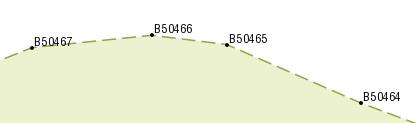
Sample image at scale 1:5,000.
Real estate plans
The layer contains the real estate plan and plot division.
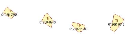
Sample image at scale 1:5,000.
Detailed development plans
The layer contains plans that apply as detailed development plans:
- detailed development plan
- urban area development plan
- building plan
- subdivision plan
The layer also contains:
- established master plan
- area regulations
- delimited area for the allocation of street costs
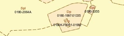
Sample image at scale 1:5,000.
Amendment of detailed development plans
The layer contains detailed development plans and area regulations that have been changed:
- amendment of a detailed development plan
- amendment of an area regulation

Sample image at scale 1:5,000.
.
Documentation
The versions of the services may overlap, so pay attention to which version you pick up at home. The version history describes the changes that occurred at each update.
| Version and date | Change since previous version |
|---|---|
|
Version 1.0 New versionAvailable 2022-05-02 |
New view service |
Technical framework and standard for view services
Our map and image view services are based on the standardized call interfaces Web Map Service (WMS) and Web Map Tile Service (WMTS) developed by The Open Geospatial Consortium (OGC). WMS is also an ISO standard (ISO 19128).
The Open Geospatial Consortium website (new window)
The services are of the nature 'question-answer', where the consumer (user's system) sends a service call over the Internet and receives a map image in a standard image format or in a vector format for certain types of services.
The characteristics of the map image are defined by the call parameters, such as information type, geographical spread, reference system, image format and image size.
There are many client applications for display services or components for integration into own system available. In addition to commercial products, there are a number of established products based on open source code, such as QGIS.
At OSGeo, The Open Source Geospatial Foundation you can read more about software in the field of geodata that are based on open source code.
Do you want deeper technical information about our geodata products you can read the product documentation.
Our geodata products with API:s require that you have an application or software capable of managing the services. To view real property information or maps directly in your browser, you can use Lantmäteriet's e-services.
Order product
You can order geodata products directly from us or from one of our resellers.
Order from Lantmäteriet
If you want to order directly from us at Lantmäteriet you should use the Order form.
To use our geodata products, you need a license for use.
In the order form, you can both order geodata products and apply for a license agreement.
Order from resellers
If you need help with ordering our geodata products or get a customized solution for your business, you can contact one of our geodata resellers.