

Contents of this page may be automatically translated, we take no responsibility for the accuracy of the translation. Feel free to contact our customer support centre if you have any questions.
A coordinate transformation is a conversion of coordinates from one coordinate system to another. Depending on the application, different transformation methods are used.
Background
Coordinate transformations are made, for example, to be able to present different sets of data together if the different sets of data are not already reported in the same coordinate system.
The term coordinate transformation can be used generally for all functions where you transfer given point coordinates in a coordinate system (from-system, or source system) to a new set of coordinates in another coordinate system (to-system, or target system).
Definition based transformations
Definition based transformations are used for transformation within a reference system.
In this type of transformation relationship, the transformation parameters are determined as fixed constants. To distinguish this type of transformation, there is a special term; coordinate conversion.
Examples where definition based transformations are used
- Conversion of coordinate formats, for example from geocentric SWEREF 99 to latitude, longitude and height above the ellipsoid in SWEREF 99:
(X, Y, Z) Û ( j , l , h). - Map projections, for example from latitude and longitude in SWEREF 99 to SWEREF 99 TM:
(j, l ) Û (N, E). - Changing the central meridian, for example from SWEREF 99 12 00 to SWEREF 99 TM:
(N, E) Û (j, l) Û (N, E).
Empirical transformations
Empirical transformations are used for transformation between two reference systems.
In empirical transformations, the parameters are developed through some type of fitting, for example unitary transformation, Helmert transformation or direct projection (projection fitting). The parameters are thus determined by fitting a number of measured fitting points.
Examples where empirical transformations are used
- Datum change, for example from geocentric RT 90 to geocentric SWEREF 99:
(X, Y, Z) Û (X, Y, Z). - Planar transformation, for example from RT 90 5 gon V 0: -15 to a local coordinate system:
(x, y) Û (x, y). - Direct projection, for example from latitude and longitude in SWEREF 99 to a local coordinate system (RIX 95 transformations are usually of this type):
(j, l) Û (x, y).
Estimation
Estimation means determining the numerical values of the parameters of a transformation formula, based on a set of points, the fitting points, which have known coordinates in both the from- and to-systems. Different transformation methods require different numbers of fitting points to provide an unambiguous determination of the parameters.
| Transformation method | Number of fitting points |
|---|---|
| Translation | 1 |
| Unitary | 2 |
| Helmert, two-dimensional | 2 |
| Affin | 3 |
Since the coordinates of the fitting points have been obtained by some measuring procedure, they are not free of errors. To minimize the effect of the errors in the coordinates on the calculation of the parameters, more than the number of common points required is normally used. It is also desirable that the points are well spread over the area to be transformed. When more points than those required are used, the parameters are calculated using the least squares method, thereby minimizing the contradictions between the coordinates of the fitting points in the from-system and the corresponding coordinates obtained by transforming the coordinates in the to-system. The approach also provides an opportunity to estimate how much the transformation contributes to the error in the transformed coordinates.
Different transformation methods in two dimensions
Translation
 Translation is an empirical transformation method that is defined by a displacement of the origin by two constants; one in the x-direction and one in the y-direction.
The parameters x0 and y0 can be determined by an adjustment procedure.
In the special case where translation is used to compensate for a local origin, however, the parameters are by definition.
Formulas
The formulas for a translation are:
xt = x0 + xf
yt = y0 + yf
where (xf, yf) are coordinates in the from-system and (xt, yt) are the coordinates in the to-system.
Unitary transformation
 Unitary transformation is a type of uniformity transformation with three parameters. It is an empirical transformation method, where the parameters are determined by an fitting procedure.
The parameters are:
- Two translations, x0 and y0
- A rotation, α
The transformation method is used in cases where the scale is to be unchanged between the from- and to-systems Unchanged scale is in some cases a condition where measured lengths and areas must be unchanged.
Formulas
The formulas for unitary transformation are:
xt = x0 + xf · cos α - yf · sin α
yt = y0 + xf · sin α + yf · cos α
Helmert transformation
Helmert transformation is defined by four parameters and is the most common planar transformation method in geodesy.
 The method is useful when the systems do not have coincident origins, that the coordinate axes are not parallel and that the systems do not have the same scale:
- Two translations, x0 and y0
- A rotation, α
- A scale factor, m
This means that the shape of objects does not change during a Helmert transformation.The method is an empirical transformation method and the parameters are thus determined by an adjustment procedure.
The figure gives you an idea of what the relationship can look like in principle.
Formulas
Denote the coordinates in the system we transform from with (xf , yf ) and the coordinates of the system we transform into (xt , yt ). The following relation then applies to any point:
xt = x0 + xf · m · cos α - yf · m · sin α
yt = y0 + xf · m · sin α + yf · m · cos α
where (xf, yf) are coordinates in the from-system and (xt, yt) are the coordinates in the to-system.
The formulas above consider the shift of the origin (x0 , y0), that the coordinate axes of the two coordinate systems are not parallel and the rotation α. To compensate for the difference in scale, the coordinates in the from system are multiplied by the scale factor m.
The equations are modified by
a = m · cos α
b = m · sin α
and we get
xt = x0 + a · xf - b · yf
yt = y0 + b · xf + a · yf
We usually call the quantities x0 , y0 , a and b for the Helmert parameters. As mentioned in the introduction, the numerical values of the parameters are determined by fitting.
Affine transformation
 Affine transformation can be used when there is a risk that the scales in the x and y directions are different, for example when digitizing from paper maps that have changed shape.
Affine transformation is a deforming transformation method. The method is an empirical transformation method and the parameters are thus determined by an fitting procedure. The parameters included in the method are:
- Two translations, x0 and y0
- One rotation, a
- Two scale factors, mx and my
- Lack of rightness, affinity, b
Formulas
The coordinates in the system we transform from are denoted by (xf , yf ) and the coordinates in the system we transform to by (xt , yt ). The formulas can then be set up as:
xt = x0 + xf · mx · cos α - yf · my · sin (α + β)
yt = y0 + xf · mx · sin α + yf · my · cos (α + β)
where (xf, yf) are coordinates in the from-system and (xt, yt) are the coordinates in the to-system.
The formulas above take into account the translation of the origin (x0 , y0 ), that the coordinate axes of the two coordinate systems are not parallel, the rotation a and the shear b. To compensate for the difference in scale, the coordinates in the from-system are multiplied by the scale factors mx and my .
The equations are modified by
a = mx · cos α
b = -my · sin (α + β)
c = mx · sin α
d = my · cos (α + β)
to get
xt = x0 + a · xf + b · yf
yt = y0 + c · xf + d · yf
The quantities x0 , y0 , a, b, c and d are usually called the parameters of the affine transformation. As mentioned in the introduction, the numerical values of the parameters are determined by fitting.
Different transformation methods in three dimensions
Helmert transformation
Three-dimensional Helmert transformation is defined by seven parameters and is therefore also called 7-parameter transformation.
This type of transformation is used in conjunction with Cartesian three-dimensional coordinate systems, which are usually located geocentrically (or near geocentrically), that is, the origin coincides with the earth's physical center of gravity.
Three-dimensional fitting formulas are calculated from empirical data in a similar way as with horizontal adjustments, but with three coordinates (X, Y, Z) given for each fitting point in the from- and to-systems.
Three-dimensional similarity transformation
(7-parameter, Bursa-Wolf)
A uniformity transformation is defined by:
- Three translations: DX, DY, DZ
- Three rotations; one around each coordinate axis: wX , wY , wZ
- A scale change, commonly expressed as a scale correction in ppm: d
In matrix form, the formula is:

Where R is the rotation matrix according to:

The strict inverse of the same formula is set up according to:
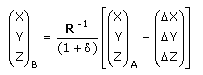
Where R -1 is the inverse matrix of R. For rotation matrices, R -1 = R T , that is, the inverse is equal to the transponate of the complete rotation matrix R. (The transponate of a matrix is obtained by reversing rows and columns in the matrix.)
Note that the 7-parameter formula can be set up in slightly different ways, in terms of the order of the operations and how signs of rotations and scale factor should be interpreted. Therefore, when entering parameters in a program you should always make sure that the program applies the same conventions as the program used for estimating the parameters.
As a minimum, you should verifiy the entry by using a control point with known from- and to- coordinates.
X, Y, Z to latitude, longitude, ellipsoid height
The transformation between geocentric and geodetic coordinates takes place with a definition based transformation.
There are several different approaches to transforming between geocentric coordinates (X, Y, Z) and geodetic coordinates (latitude, longitude and height above the ellipsoid).
In the formula description below, a closed approximate formula is used, but iterative procedures are also common. The difference between the closed formula and an iterative procedure can amount to a maximum of one tenth of a millimetre for common applications in Sweden (height <20,000 m).
The formulas used to convert between the different coordinate types are given, together with a numerical example, in the document Transformation between geocentric Cartesian coordinates and geodetic coordinates (pdf, in Swedish, new window).
