
 A smarter process for urban planning and building
Contents of this page may be automatically translated, we take no responsibility for the accuracy of the translation. Feel free to contact our customer support centre if you have any questions.
Lantmäteriet is proposed by the government to be given the formal task of establishing the basic data domain property information and geographical information, ie to adapt and implement the framework for National basic data on information about properties and geographical information.
Lantmäteriet´s assignment - to establish the basic data domain geodata
The assignment means that Lantmäteriet by ordinance or amendment in the instruction is expected to have a designated coordination responsibility for the management of basic data within the Lantmäteriet data domain real estate information and geographical information. with existing Geodata Council .
At the national level, there is also the establishment of a basic data domain company, led by the Swedish Companies Registration Office and a basic data domain person, led by the Swedish Tax Agency. An investigation is also underway into whether a health domain and a transport domain should be established. In addition, the government has commissioned the Swedish Companies Registration Office, the National Land Survey, the Agency for Digital Administration, the Agency for Civil Protection and Emergency Planning and the Swedish Tax Agency to jointly establish a national framework for basic data in public administration. The authority for digital administration shall lead the work and manage the results.
For more information:
A smarter process for urban planning and building will be the starting point for the basic data domain geodata
Through the work with the government assignment - To establish a national infrastructure for at least two data sets in the community building process, Lantmäteriet has already created a broad collaboration and an ability to create nationally standardized data sets through so-called national specifications and make the information publicly available via machine to machine services. The collaboration within a smarter process for urban planning and building will therefore be the starting point for the basic data domain geodata.
Within the Government assignment, two data sets, building and detailed plan, were adapted to the information architecture framework for geodata, which is based on the national framework for basic data, but which is strengthened in parts needed in the real estate and geographical information domain.
The data sets will in 2022 be published on the site dataportal.se (new window)
For more information
- The final report for the government assignment (pdf, in swedish, new window)
- a smarter process for urban planning and building
- National information architecture framework
- Read more about national specifications
How will the work of establishing the domain be carried out?
Establishment of basic data domain geodata will be implemented within the framework of the Geodata Council's action plan and be a further development of the government assignment - To establish a national infrastructure for at least two data sets in the community building process. Lantmäteriet also continues to produce new basic data sets, within the framework of the special allocation allocated for the work on a smarter process for urban planning and building.
You can follow the progress here.
The framework for national basic data sets requirements for how the basic data domain authority and basic data producers must handle national basic data. Lantmäteriet works together with the authorities in the Geodata Council to prepare for, provided that mandates and funds are decided by the government as expected, to best maintain a high capacity in adapting data sets to the national framework and the extended geodata framework.
The National Land Survey, in collaboration with the members of the Geodata Council, has decided on a proposal for the domain:
- organization and roles.
- principles for assigning responsibility as Model and Specification Manager.
- process and documentation to make decisions about the start-up and implementation of work with new data sets to national specifications.
- decision-making process and documentation of decisions of new or revised specifications.
- decided thematic division of the domain, content in themes including overall information model.
In 2022, work will continue to prepare the establishment of the basic data domain in collaboration with the members of the Geodata Council.
Organization and Roles
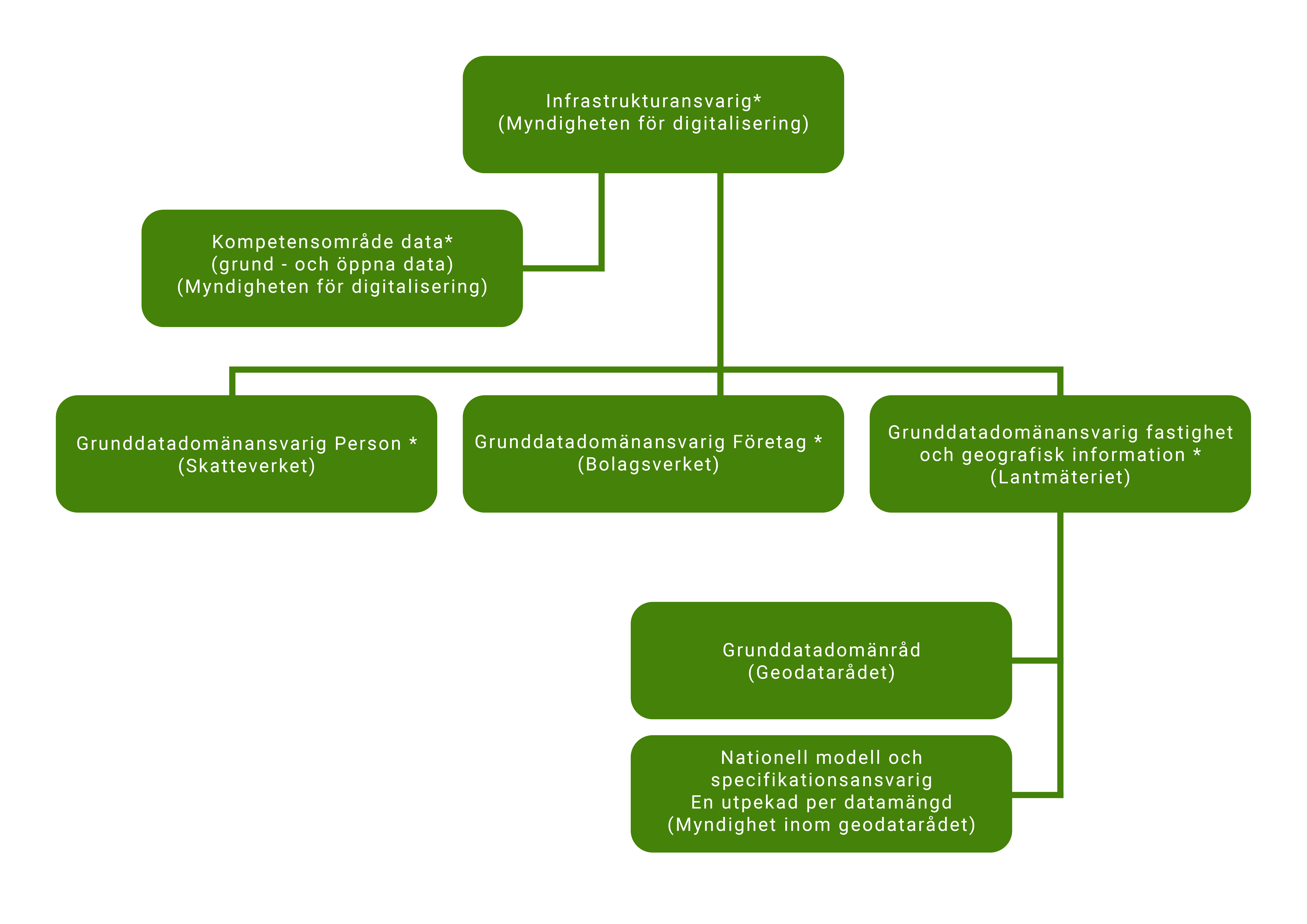
Roles in the organization marked with * are decided within the overall structure within ENA - Sweden's digital infrastructure, other roles have been developed based on needs within the basic data domain property and geographical information.
Role of Infrastructure Manager
Description: An authority that is responsible for the development and management of the infrastructure, where assignments must be stated in the constitution. Responsibility and authority include coordinating and leading the work for strategic, tactical and operational management, as well as appointing participants to these forums. Will initiate exploratory development in order to add new building blocks and new basic data domains.
Established role of DIGG.
Role Competence area manager
Description: An authority that is responsible for an area of competence where assignments are given by the infrastructure manager. The responsibility for providing support to actors in the infrastructure at central and local level.
Established role of DIGG.
Role Basic data domain Responsible (decision maker)
Description: Authority that is responsible for the development and management of assigned basic data domain, where assignments must be stated in the constitution. The master data domain manager has responsibilities and powers linked to his master data domain. The role must relate to the overall control within the infrastructure, but can also exercise control within its basic data domain. The basic data domain manager collaborates with competence areas, other basic data domains and other relevant actors.
Established role of DIGG.
National Model and Specification Manager
Description: An authority designated as responsible for a theme or a set of information, where assignments are given by the basic data domain manager. Does not have a national supply responsibility, unless this is the responsibility of the authority according to another role or law.
Role of the domain's needs.
Principles for assigning responsibilities as Model and Specification Manager
In cases where a responsibility is assigned to an authority by decree or instruction, responsibility for the national information model and specification shall be assigned to the same person responsible.
In cases where a responsibility is designated for the amount of information / theme within the Regulation on environmental information, responsibility for the national information model and specification shall be assigned to the same person responsible. In cases where the municipalities are responsible, the assignment of national specification must follow as follows.
If no previous liability has been identified in other legislation, the following should be assessed in order of priority before a decision:
- The authority has its own production and use and thus good knowledge of the amount of information.
- The authority has a major impact on the content of the information model from the legal impact of its development or use.
Process for creating new or revising national specification
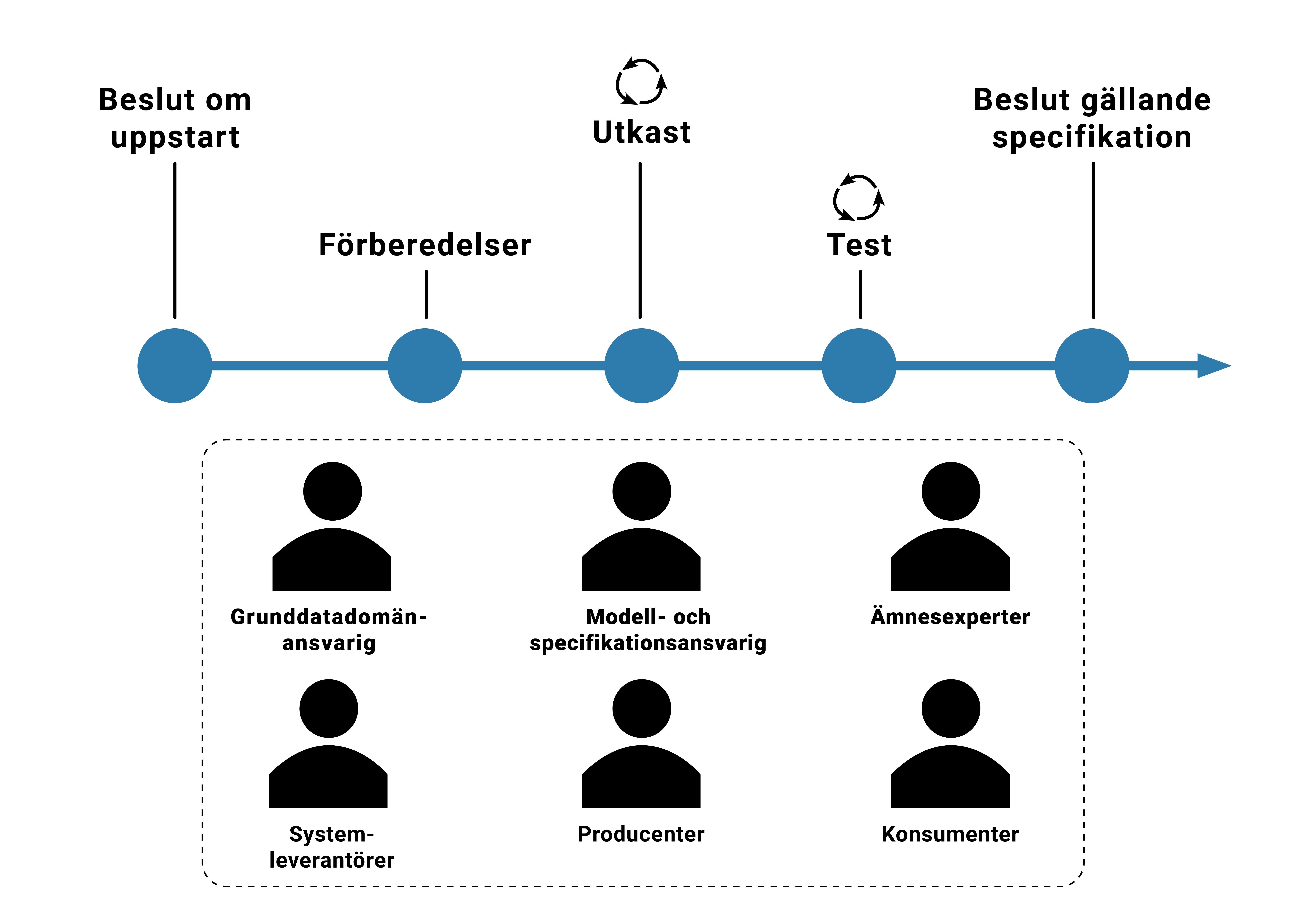
Regardless of the type of specification that is produced, the process is largely the same. There may be some variations in scope and which steps need to be implemented. The process is performed in five different steps, where some of the steps are iterative:
- Decide on developing a national specification
- Prepare the work
- Prepare a draft
- Test the specification
- Decide that the specification will apply
In the first stages, the work takes place a lot within the business, and it is only at the end of the draft stage and in the testing of the specification that the technical development comes.
Throughout the work, many different actors participate to ensure that the specification is good and will be used. It is, for example, subject matter experts, system suppliers, data producers and of course also those who will use data. If a national data product specification is produced, Lantmäteriet also needs to be involved as a setter of requirements based on the National Geodata Platform.
Decision document
A template has been produced for the job description and decision basis of a new or revised national specification.
Template for description of work and decision basis (dotx, in swedish, new window)