

Contents of this page may be automatically translated, we take no responsibility for the accuracy of the translation. Feel free to contact our customer support centre if you have any questions.
Here you can read about what is in the National Board of Surveying and Mapping's archive (LMS archive).
Content of the archive
The LMS archive contains material from the year 1628 and all the way into the 20th century. Here are road maps, county and landscape maps, general maps, parish maps, city maps, geometric land registers and renovations, hand-drawn copies, of land survey large-scale maps and other administrative material. The maps are usually in a scale of 1: 5,000 and larger.
Geometric Earth Books (1630 - 1650)
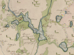
The geometric land registers (1630-1650) contain the oldest large-scale maps we have in our country. A main task for Lantmäteriet after its formation in 1628 was the mapping of villages and homesteads and their property. It was mainly the krono and tax homes that were interesting.
Maps were drawn up of fields and meadows and returns and other conditions of an economic nature were reported. Whether the intention from the beginning was that the maps would be used as a basis for taxation is unclear. They can in any case be considered as precursors to the economic maps of our time.
The maps occur unevenly across the country. They are collected by parish and district in large volumes. The geometric land registers should not be confused with the Crown's ordinary land registers, which were, after all, lying over land properties with information about their camera conditions. The Crown's land registers can be said to be the first property register and the geometric land registers the first register maps.
From the period 1630 to 1650 there are about sixty volumes. The scale is usually 1: 5000.
The National Board of Surveying and Mapping's map archive also contains about a hundred volumes with maps from the latter half of the 17th century and a bit into the 18th century called geometric land registers. They are drawn up in varying scales, but most are large-scale. These are home maps that have largely been created during regular taxation, militia taxation for the subdivision agency's implementation or investigations regarding the exchange home in connection with the reduction.
See also Riksarkivet older geometric maps (new window).
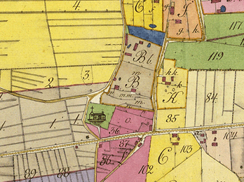
Shift maps (1750 - 1927)
Here you will find material that has been collected in the National Board of Surveying and Mapping's map archive for approximately 350 years. Here you will find, among other things, large-scale and legal parcel maps.
Parcel maps here refer to e.g. large-shift, single-shift and fixed shift maps. The oldest hand-drawn maps were each produced in one copy only.
As Lantmäteriet set up regional offices, the instructions were changed so that the surveyor, from the basic or concept map he had drawn up, was obliged to make a clean drawing - a so-called renovation.
The reindeer drawing would be delivered to the central office in Stockholm for review. Most ordinances / maps were produced in triplicate. The first copy was kept by the regional authority under the concept of concept. The second copy stayed with the owner / village team and the third copy - the renovation - was sent to the central authority in Stockholm for review. The obligation to renovate gradually thinned out and formally disappeared some way into the 20th century. The renovation copies are today stored in the National Land Survey's map archive at Lantmäteriet .
The map scales were usually 1: 4,000 for the inland areas (arable and meadow land) and 1: 8,000 for the outlying areas (forest land).
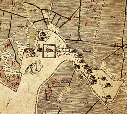
County and landscape maps (1745 - 1843)
A number of geographical maps of parishes, districts, provinces and counties had come into the surveying office during the lively cartographic activities of the 17th century.
On the basis of that material, e.g. Director of Surveying Gripenhielm prepared his general map of Sweden (1688). The general map 1706 is also the result of the survey's early geographical activities.
The surveyors sent these works to the surveying office where they were transformed into a smaller scale. The result was provincial maps of almost all Swedish landscapes. Most have no author. Whether all are from the 17th century is uncertain. Some are probably compiled during the first years of the 18th century. Gripenhielm's application to the government in 1689 for permission to print the drawn up provincial maps was rejected. The 1725 instructions emphasized the secrecy of the maps again.
With regard to charts, on the other hand, the practical needs for shipping had forced publication. A new lake atlas was prepared and published in 1738. Simultaneously with that work, the question of publishing maps was also raised. Lantmäteriet 's request to the Riksdag was approved. In 1735, the survey was granted the privilege of publishing geographical maps.
A copper printing house was established at the surveying office for this purpose. The engineer and engraver Georg Biurman became the director. Several landscape maps and a Mälaren map were produced, but the poor interest from the public as well as from the government caused financial problems. The business was closed down. Under Biurman's direction, a semi-official publication continued which, however, stopped at his death in 1755.
Despite this, in the following years several provincial maps were made, engraved and printed for publication in the surveying office and published in its name. The maps that were printed and published under the auspices of the Surveying and Mapping Office are collected in a bound volume entitled 'Af Kongl. Maps published by the General Land Survey '.
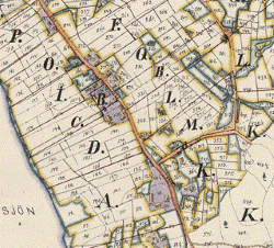
Parish maps (1845 - 1859)
In the National Board of Surveying and Mapping's map archive, there are a number of parish maps from different time periods. There are mainly two periods that stand out. The first period extends from the end of the 17th century to the first decades of the 18th century. The second period, which we have chosen to publish, runs from 1845 to 1859 when a uniform parish material emerged in a parish map within the National Board of Surveying and Mapping.
The direct background to this work can be found in the need for a more detailed statistical knowledge about Sweden and the question was discussed at the Riksdags in 1815 and 1823.
At the same time as the statute on legal change was decided in 1827, a new surveying instruction was also issued. It established the organization and the surveyors' tasks and duties on various services. In addition, provisions were made for the establishment of geographical parish maps. In the same year, a model for parish maps and forms for description was prepared, which, however, was not established until 1845, when the work also began. The work was carried out in the Parish Map Agency, which was a unit under the National Board of Surveying and Mapping.
The purpose of the parish maps was stated to be to obtain information about the country not only statistically, but also geographically and economically. Part of the description would consist of a table with columns for, among other things, taxes, costs for armament, poverty alleviation, postage and road maintenance, the number of residents on a homestead, mantal, the homestead's so-called nature (krono- tax and salvation), mills, saws, mills and other establishments.
The description would also describe the general geographical conditions of the parish, the population and its changes, what was characteristic of the dress, how one lived, for customs and usages, for the principal and binary industries, how it was arranged with schools and poverty alleviation, for parish magazines and much more. Ancient monuments and natural monuments as well as what was told about strange people and events were to be noted. In addition, a description would be made of the church, strange graves and tombstones and more.
The work with the parish maps lasted for 14 years. More and more of the surveying 's resources had come to be used for the land administration. This led to the Sockenkarteverket being separated in 1859 from the survey. The National Economic Mapping Authority was established instead where the maps were handed over. However, they were later moved back to the National Board of Surveying and Mapping's archives.
The archive contains 272 maps and 244 descriptions. The collection has uneven coverage across the country. Stockholm s län, which has the most, has 50 maps while e.g. Södermanland s län has only one.
In addition to the maps that were drawn up within the framework of the parish map system, a number of parish maps that were drawn up decades before 1845 have also been included here.
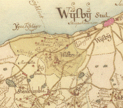
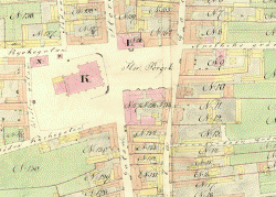
City maps (1630s - 1974)
The survey of cities began as early as the early 17th century. The measurements concerned both new urban facilities and re-regulation of the old cities. The mapping of cities was intensified during certain periods, often in connection with various regulations such as fire insurance and town planning.
In addition to city maps from the National Board of Surveying's map archives, three atlas works by three different cartographers have also been included - Wiblingen, Werming and Ljunggren. The hand-drawn map material is by Fredrik Adolf Wiblingen, who in 1784 was admitted to Lantmäteriet , from which he requested resignation in 1790.
He opened a 'map copy two years later and reindeer drawing office 'on Tjärhovsgatan in Stockholm . Until his death in 1805, he came here to order for government works and individual prefabricated maps. He was particularly active in the last years of the 18th century. Today, his hand-drawn maps can mainly be found in the War Archives and Uppsala University Library and at the Royal. The library. The maps found in Historical Maps only reproduce the material in the War Archives.
After Wiblingen's death, War Councilor Carl Peter Hagström tried to take over his privilege. Hagström had in parallel with Wiblingen during the first years of the 19th century copied city maps. The majority of Hagström's maps are today in Kungl. The library and Uppsala University Library. At the same time, the engineer at Lantmäteriet , Nils Gustaf Werming, had begun work on supplementing Samuel Gustaf Hermelin's atlas works across Sweden with a number of city plans. Under Historical Maps you can find most of these 51 sheets.
The last map series that is represented is made by the engineer at Lantmäteriet , Erik Gustaf Ljunggren. In connection with an investigation in the middle of the 1850s (Committee for the Examination of the Basics of City Taxation), Ljunggren was given the opportunity to publish 'Atlas of Sweden's cities with their property', on a scale of 1:20 000. In 1859 Ljunggren became director of the then recently established the National Economic Mapping Authority. There he could continue his thematic publication - mainly with the so-called "district economic map".
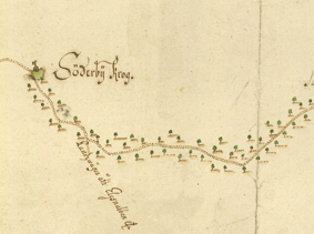
Road maps (1731 - 1742)
Already in the 1643 instructions for the geographical mapping, roads were an important detail. For traffic and postal service as well as for military needs, it was important to know the length and length of the roads, as well as the location of transport stops and inns. also reported cities, churches, manors, post offices and inns, villages and homes along the roads.
From the beginning of the 18th century, there are some road maps that were drawn up in connection with the creation of new postal routes. In 1730, the survey, by royal decree, was ordered to prepare new maps of public country and postal roads in Sweden and Finland. The maps were to be sent to the King. Maj: t. In the following years, such maps were drawn up for 17 counties. The maps were re-drawn in the central surveying office in the years 1735-1742, where they are still kept bound in a volume: 'Chartebok öfwer Landswägarna uti Swea och Göta Riken förfärdigad wid Kongl. Lantmätericontoiret '.