

Contents of this page may be automatically translated, we take no responsibility for the accuracy of the translation. Feel free to contact our customer support centre if you have any questions.
The property boundary is the dividing line between properties. It goes between the boundary points that are usually decided at a surveying service, marked by boundary markings on the ground and reported on the administrative map.
It is important to find the boundaries
Property boundaries and landmarks are of great importance for the use of the land and often for neighboring Jan. The boundaries determine the extent of the property on the land and what you own. Knowing the location of the border and what you can and cannot do with or near it is important when, for example, buying a property, building permit, deforestation, hunting, fishing, setting up fences and planting hedges.
Old boundary marks can be difficult to find
You can use our service My property, there you can take advantage of administrative maps where it is clear where boundary marks for your property are located.
Sometimes it is difficult to find the boundary markers on the ground. Many came into being more than 100 years ago and may be overgrown today. Machinery in forestry and agriculture, road construction and other construction work have destroyed many brands.
Do the borders show correctly? Watch our film which informs more about this: Finding your boundaries.
Questions and answers about borders and border markings
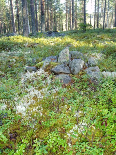
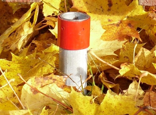
The boundary marker is usually a raw stone or a pipe in the ground.
Råstenen is the most common of older boundary markers in rural areas and in forest land. It generally consists of a raised rocky top, slightly buried. It is schooled around with smaller stones and stone fragments. Sometimes brick fragments or charcoal were placed under the mound to show that it was a work of human hands. In some cases, the raw stone may consist of an earth-solid stone, but is then often in some way marked with some incision and rounded to mark its status.
Pipes that have been driven into the ground are today the most common boundary mark. There are also holes or studs in stone or rock. (sometimes surrounded by a hewn square), wooden poles (in bogs) and pipes that are attached to stone or rock or cast in cement.
Sometimes you can be wrong because not all markings or claims are property boundaries. In urban areas, it is common for retaining walls, hedges, fences, planks, etc. to be a sign of a claimed boundary. no text on the marking so it is not clear what its purpose is.In addition, there may be other pipes protruding from the ground, such as water pipes.
According to a provision in the Land Code, the boundary marking is what primarily legally shows where the property boundary between properties is located. When properties are created, boundaries are decided upon and marked so that it will be possible to claim the property.
A limit that has been added at Surveying or the like is legally determined and these are boundaries of the type discussed here. Examples of boundaries that are not legally determined are boundaries around allotments, parcels and leasehold plots.
As a landowner, you can independently search for your own boundaries, chop up the boundary line, paint trees in the boundary line and cut down piles that mark the border and clarify markings with color, (preferably white or dark red), markers, sticks and so on.
Doing this with the landowner or landowners you share boundaries with avoids many unnecessary conflicts. It is also wise to contact the neighbor before starting something that may affect his property, such as building fences, walls or building hedges in the border.
When buying a property, it is good to have the boundaries clear. Always ask the seller to show you where the boundaries go and where any boundaries are.
No, it is a criminal offense to destroy or alter a boundary marker. It is therefore not permitted to, for example, disturb or cut existing boundary pipes. Of course, it is also a criminal offense to intentionally move a boundary marker. In addition, you must not simply build in or too close to a border or otherwise affect a neighbor's ability to use their property.
If you know that a landmark will be damaged, you can get help to ensure its position, by having it measured. If you accidentally destroy a mark - fill it a lot, dig or plow it away - you must not put it back on your own where you think it was. Marking of boundary points is a task for the Lantmäteriet .
Old boundary marks - even those that no longer have any function - can be legally protected as cultural monuments.
Using maps, information from previous owners, and from current and past neighbors, you can usually find out where any marker is or where parts of a boundary are clear. In woodland, you can conveniently start by looking for markings in endpoints or corners, as these markings are usually larger and clearer than markings in between.
Do you find a marking or detail on the map such as houses or ditches which are still there, you can take approximate measurements from there. Then you look for more signs on the ground where you think something should be there. Raw passages in the forest and fences as well as stone walls gossip that there is a border here. It also happens that boundaries in the forest are marked out with aluminum piles.
Examples of different signs in nature that indicate that there is a claimed boundary are;
- differences in the stocks in forest land such as forests of different ages.
- bleces in trees. Therefore, do not remove trees with such if they can be saved to show the roughness.
- twig and stripped sticks (usually spruce). Put them back up if they have fallen over.
- ditches.
In forest land, there are often so-called outriggers and hands about 20 meters from the rock in the direction of the border. Outriggers and hands are an elongated upright stone that points in the direction of the border. There can also often be three wooden poles in the direction of the boundary line in bogs. Handers were often placed at heights and crests in the terrain.
Sometimes there are measurements on the map that can be used. There may also be location information in the form of coordinates on the map (points measured from known marks or special measuring points) or in an appendix to the map (technical description). In densely populated areas, the measurements are usually given with great accuracy - on the centimeter when.
The maps and documents created at surveying services and which describe when the property was formed is the most important tool for seeing where boundaries go. In addition, you have good help from the register map. The register map is available at Lantmäteriet . I Urban areas often have maps on a larger scale, such as primary maps and base maps, which are available from the municipality.
On Lantmäteriets business maps, you often see the type of marking used to mark your particular boundary. Each boundary marker is then named with an abbreviation. Below is a list of the most common abbreviations used on business maps. Did you find an abbreviation on your map that is not included below? Welcome to contact Customer Center and they will help you .
Abbreviation - Marker type:
Db - Stud in mountain
Dg - Stud in concrete casting
Ds - Stud in stone
Grg - Old pipe in concrete casting
Grn - Old råsten
Grm - Old pipe in the ground
Hb - Borehole in rock
Hg - Borehole in concrete casting
Hs - Borehole in stone
Om - Unmarked point
Rb - Pipe in rock
Rg - Pipe in concrete casting
Rm - Pipe in ground
Rn - Råsten
Rs - Pipe in stone
Tp - Wooden pole
Sa - Nail in asphalt
Sb - Nail in mountain
Sg - Nail in concrete casting
Ss - Nail in solid stone
St - Post
Separation was a private division of land with limited authority where the transfer document is central. The measure could be implemented until 1928 when the Land Division Act came into force, and until 1917 not even a map of the borders was required. rights that would accompany the new property.
In the event of a separation, the property boundaries are not legally determined. In case of ambiguity regarding the legal status of the boundary, a property determination may therefore be required to clarify the legal boundaries of a detached property.
More information about property determination can be read here.
Lantmäteriet only measures boundary points for a property in connection with a surveying service . This means that the only account available is in the coordinate system that was relevant at the time of the service.
If no one applies new surveying service, no measurement is made and the old coordinates remain, and are thus the only coordinates that Lantmäteriet has regarding the property. missing markings on the ground, in the alternative, information may be retrieved from the administration map and other documents. Lantmäteriet does not carry out assignments regarding transformations of coordinates for property boundaries .
The e-service Coordinate transformation supports transformation between coordinate systems based on RT 90 and SWEREF 99.
In the e-service My Map allows you to produce approximate coordinates in SWEREF 99 TM for property boundaries.