

Contents of this page may be automatically translated, we take no responsibility for the accuracy of the translation. Feel free to contact our customer support centre if you have any questions.
Compute geoid heights using the geoid models SWEN17_RH2000 and SWEN17_RH70.
About the geoid
Today it is becoming increasingly more common that satellite techniques are used for positioning. This results in heights relative to a reference ellipsoid. To convert the height above the ellipsoid, h, to the height above sea level, H, the separation between these two surfaces must be known. This separation is called the geoid height N; see the figure and the equation below.
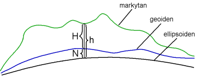
h = H + N
SWEN17_RH2000 is a geoid model that is adapted to SWEREF 99 and the height system RH 2000. SWEN17_RH70 is the corresponding model for SWEREF 99 and the older height system RH 70. More information about the geoid models can be found under the pages about the geoid.
Calculate the geoid height
Enter latitude and longitude in SWEREF 99 to calculate the geoid height. Latitude and longitude are given as decimal degrees (dd.ddd ...), degrees and minutes (dd mm.mmm ...) or as degrees minutes and seconds (dd mm ss.sss ...); all with decimals, if any.