

Contents of this page may be automatically translated, we take no responsibility for the accuracy of the translation. Feel free to contact our customer support centre if you have any questions.
The postglacial land uplift in Sweden affects our geodetic reference frames and is an important component when reducing coordinates to a certain epoch.
About the land uplift
Here we refer to postglacial land uplift as the return of the earth crust to its state of equilibrium after having been heavily loaded by the kilometre-thick ice during the last Ice Age. When the ice started to melt approximate 20 000 years ago, the pressure on the earth crust was relieved and the land started to rise. The last ice disappeared from Scandinavia about 10 000 years ago. Because of the highly viscous behaviour of the interior of the Earth it will take a very long time before it has returned to its state of equilibrium. Until now, the land has risen several hundred metres and it is estimated that there are several tens of metres to go. In Sweden, the land uplift rate varies; it is largest in the north along the coast of the Baltic Bay (around 10 mm/year) and smallest in the south (around 1 mm/year).
Observing the land uplift
As early as in the 18th century it was observed that the Earth's surface was rising in the Nordic area. At that time it was believed that this was due to a lowering of the sea level and the phenomenon was called 'water diminution'. Following a suggestion by the scientist Anders Celsius, water level marks were cut into cliffs and rocks along the Swedish coast. Today the sea level is automatically recorded by permanent tide gauges. Land uplift can also be determined by other types of observations, such as repeated levelling, GNSS and observations of ancient shore lines (which now lie on dry land).
Depending on what the land uplift is related to, we distinguish between
- absolute land uplift: land uplift relative to the centre of the Earth
- levelled land uplift: land uplift relative to the mean sea level excluding present climate related effects (the geoid)
- apparent land uplift: land uplift relative to the actual mean sea level.
The postglacial land uplift, which is also accompanied by mass changes inside the earth, also affects the gravity field of the Earth, even though this change is rather small. This causes changes in both the geoid and gravity field which means that for very accurate applications also gravity values must to be referred to a certain epoch.
The land uplift model NKG2016LU
In 2016 the Nordic Geodetic Commission (NKG) released the land uplift model NKG2016LU. It is used as an official land uplift model in Sweden, as well as the other Nordic and Baltic countries. The model is based on repeated precise levelling and data from permanent GNSS reference stations. For the area outside the Nordic countries the land uplift has been computed using a geophysical model, which is based on models of the ice history and the geophysical properties of the Earth's mantle and crust.
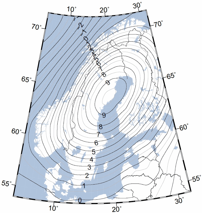
The figure shows levelled land uplift [mm/yr] according to the NKG2016LU land uplift model. By levelled land uplift we mean the land uplift relative to the of climate effects undisturbed mean sea level (the geoid).
Documents and files
- The land uplift model is described in further detail in NKG2016LU: a new land uplift model for Fennoscandia and the Baltic Region (new window) (Vestøl, O., Ågren, J., Steffen, H. et al., Journal of Geodesy, 2019). See also a presentation of NKG2016LU (pdf, new window)
- Download NKG2016LU including standard uncertainties (zip, new window)
- Download NKG2016LU_gdot, a model of gravity change in Fennoscandia (zip, new window)
- Read about Calculation of Historical Shore Levels back to 500 A.D. in the Baltic Sea Area due to Postglacial Rebound (Ekman, M) (pdf, new window)