

Contents of this page may be automatically translated, we take no responsibility for the accuracy of the translation. Feel free to contact our customer support centre if you have any questions.
The RAK archive contains the Economic Map, the General Staff Map and the so-called District Economic Map; three large map series describing topography, economics, buildings and communications during the 1800s-1900s. The maps are on a scale of 1: 10,000 and smaller.
General Staff Map
The General Staff Map (1827–1971) describes the natural landscape, including altitude conditions, communications, buildings and general land use. The scale is 1: 100,000 in Södra verket and 1: 200,000 in Norra verket.
In 1805 a military organization was created for the production of topographic maps - it was originally called the Field Survey Corps later - the Field Survey Brigade and finally the Topographic Corps. From 1860 onwards In 1874, the magazines were published under the name Topografiska kåren's map of Sweden.
The maps that are now in Lantmäteriet s archive (the Swedish National Mapping Authority's map archive) mainly refers to the period after 1860. From 1874 onwards, the General Staff map began to be published under the name 'The General Staff's map of Sweden', it came to cover the whole country and was widely used and distributed. in 1923. The last map was published, which also made the series nationwide. The new publication then continued partly of brand new, partly of revised leaves. 1971. Publishing however, continued well into the 1970s. The General Staff map describes the natural landscape, including altitude conditions, communications, buildings and general land use. The scale was 1: 100,000 in Södra verket and Norra verket was reproduced in 1: 200 000.
See Legend for the General Staff Map (pdf, new window)
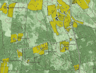
The Economic Map
The Economic Map (1935-1978) was register map and reports the properties and register designations. Residential buildings, plots and gardens, cultivation areas and ancient monuments and a large number of place names are reported. The scale is 1:10 000, except in the interior of Norrland, where the scale is 1:20 000.
The economic map has for a long time played an important role as a basis for various sectors in community planning. It is a unique time document that reflects both economic and cultural phenomena.
Background
In the 1930s, a new technology with aerial images was introduced that made it possible to map large areas at a low cost. The RT38 geodetic system was introduced and modern and uniform maps with A plan for a mapping project for Sweden at a scale of 1:10 000 was established, and for the first time both property information and geographical information with high location accuracy and great detail were gathered in a common document.
Contents
The economic map was a register map and reported properties and register designations as well as residential buildings, plots and gardens, arable land, ditches and farm roads as within the cultivation areas, are shown in detail. The unit's field inventory of ancient monuments is reported. The economic map also contains a large number of place names.
The economic map is divided into leaves of 50 x 50 cm and is in the scale 1:10 000, except in the interior of Norrland, where the scale is 1:20 000. The map has four inks; green photo image, yellow field surface, all drawn map image and the text in black as well as brown elevation curves and raster for the swamp. The lake surfaces are not depicted in blue but are depicted in the green color of the photo image.
Areas of use
in the planning of agriculture and forestry, road construction and construction of power lines and in the examination of matters concerning housing construction.
Today, the Economic Map, with all the collected information from this era, is an important source of knowledge for nature and cultural environmental protection. , for real estate development activities and community planning as well as for the agricultural and forestry industry. . However, it does not cover the whole of Sweden but only parts of Götaland and Svealand (completely in 13 counties) as well as a number of leaves in Norrbotten s county. The scale is 1:20 000 in the southern part of the country and 1:50 000 in Norrbotten .
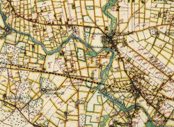
The district economic map was produced over a considerable period of time. The content, quality and also manners vary, but it is still a cohesive series. Geographical mapping had within lantmäteriet has been conducted since the 17th century and can today be found in the National Land Survey's archives in the series 'Läns- och häradskartor' or in the form of parish maps .
A direct precursor to the District Economic Map were the maps produced in connection with the Parish Map Agency, whose production in practice ceased in connection with the creation of the National Economic Map Agency in 1859. The maps from the legal shift were compiled into parish maps in scale 1: 20,000. Like the parish maps, the District Economic Maps were based on legal parcel maps and provide a good overview of land use, vegetation, buildings, communications and borders. län.
The district economic map was printed in color in the scales 1:20 000 or 1:50 000 and was gradually given a standardized leaf division. However, it does not cover the whole of Sweden but only parts of Götaland and Svealand (completely in 13 counties). However, there are background maps (frame concept versions for a few more counties and these are always in a scale of 1:20 000). These are concept versions that are digitally available via the History Maps application.
See legend to Häradsekonomiska kartan scale 1:20 000 (pdf, new window)