Contents of this page may be automatically translated, we take no responsibility for the accuracy of the translation. Feel free to contact our customer support centre if you have any questions.
Static measurement is a variant of relative measurement, where you measure for a longer period at each point and calculate the position afterwards. This procedure provides the opportunity to obtain the lowest positional uncertainty you can achieve with GNSS surveying, as you can get a better control and increased opportunities to reduce the impact of error sources when post-processing.
What is static measurement with post-processing used for?
Post-processing of static GNSS measurements with long observation times is often the most accurate way to determine a GNSS position. This gives you the opportunity to use better orbit data and make better estimates of the impact of other sources of error on the measurements. One example is that you can use post-calculated ionospheric models to reduce the impact of the ionosphere on the measurements. However, it also takes a long time to carry out static measurements and requires more follow-up work than measuring with e.g. network RTK where you can obtain calculated coordinates in real time.
Static measurement with post-processing is therefore mainly used in applications with very high demands on low measurement uncertainty, e.g., when establishing or supplementing geodetic control networks.
What is static measurement?
Static measurement means that you set-up the GNSS receiver over the point you want to position. Then the receiver stores measurements over a long period of time – ideally for several hours. You can often do the set-up very accurately with the help of a tripod and plummet which minimises uncertainty in centering over the point to be measured.
Advice and guidelines (in Swedish) for static measurement the HMK document on measurement of control networks.
What does post-processing mean?
The static measurements are then combined afterwards in the calculation with simultaneous measurements performed at one or more reference stations with a known position.
You can do the post-processing of static measurements yourself with one of the market's post-processing software, or by sending the stored GNSS observations in RINEX format to an automated internet-based calculation service, such as SWEPOS post-processing service.
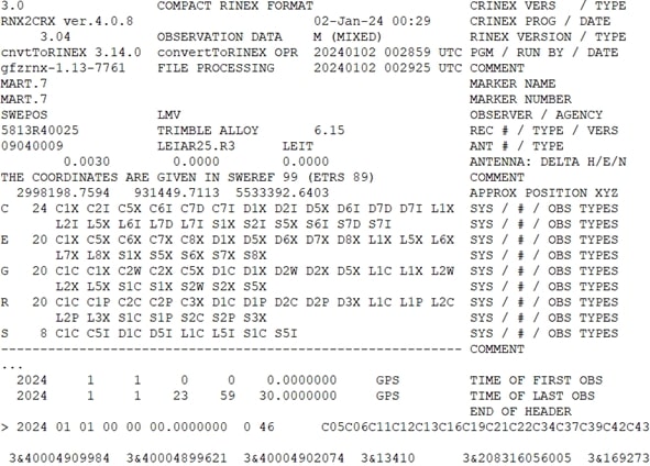
File formats used for post-processing of GNSS data
The GNSS observations from a static survey are often stored in the receiver in a manufacturer-specific format. However, it is usually also possible to export the raw data from the receiver in RINEX format (Receiver Independent Exchange format). RINEX is a receiver-independent transmission format and is the standard for raw GNSS data and compatible with most receivers and post-processing software’s on the market. A RINEX file is text-based and contains code and carrier phase observations between receivers and satellites during the measurement, as well as metadata in the file's header, such as the antenna and receiver type you used for the measurement. Read more about the RINEX format and its different versions on the IGS website (new window).