Contents of this page may be automatically translated, we take no responsibility for the accuracy of the translation. Feel free to contact our customer support centre if you have any questions.
UTM is a system of 60 projection zones in Transverse Mercator projection that covers the entire earth. UTM is an abbreviation of Universal Transverse Mercator.
UTM facts
In Europe, UTM has been commonly used in conjunction with ED 50 (European Date 1950). Nowadays, UTM is most often used in connection with WGS 84/ETRS89 (for example in Norway).
- The UTM zones are numbered 1-60 from the west (longitude -180º) and has a width of 6º.
- The central meridian is calculated from Greenwich and is in the middle of each zone. Zone 1 has a central meridian of -177º.
- To distribute the scale error over the relatively wide projection zones, a scale reduction factor of 0.9996 has been applied to the central meridian.
- North of latitude 84º north and south of latitude 80º south, a stereographic projection has been applied instead of UTM, Universal Polar Stereographic (UPS).
Exceptions from the zone division have been made in Norway, among other places.
Parameters
General parameters for UTM in all zones
- The central meridian in degrees is calculated according to the formula: zone number * 6 - 183 (from Greenwich).
- x-addition (false Northing) is 0 metres north of the equator and 10,000,000 metres south of the equator.
- False Easting is 500,000 metres.
| WGS 84, ETRS89, SWEREF 99 | ED 50 | |
|---|---|---|
| Ellipsoid | GRS 80 | Hayford 1910 |
| a | 6378137 | 6378388 |
| 1/f | 298.257222101 | 297 |
Grid zone designators
Positions in UTM are also indicated by an alphanumeric code, the Military Grid Reference System (MGRS). Each zone is divided between the latitudes 80º south and 80º north into 8º latitude bands denoted by a letter C - X, except I and O, with the letter C for the southernmost latitude band and X for the northernmost. Each zone is also divided into planar squares with 100 km side.
Global UTM overview
Some modifications of the zone division have been made in southwestern Norway and the Arctic Ocean. The deviating zone boundaries are marked in red in the overview.
- Between latitudes 56° and 64°, zone 32 has been widened to 9° latitude at the expense of zone 31.
- Between latitudes 72° and 84°, zones 33 and 35 have been widened to a width of 12°. To compensate for this, zones 31 and 37 have been widened to 9° and zones 32, 34 and 36 have been abolished in this area.
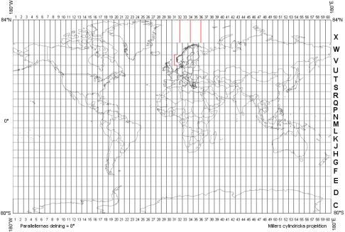
Open a larger image of the UTM zones (gif, new window).
The use of UTM in Sweden
UTM has been used in Sweden in various projects where data exchange with other countries has taken place, for example at land and sea boundary demarcations.
In these contexts, UTM has previously been linked to European Date 1950 (ED 50) , but nowadays it is usually linked to SWEREF 99 (WGS 84, ETRS89).
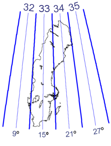
A strict application of UTM in Sweden means that UTM zones 32 to 35, as shown below, are used. The map projection for SWEREF 99, called SWEREF 99 TM, is defined in the same way as UTM zone 33, with the difference that it is extended to apply to the whole country.
The UTM network is marked (in blue) in the margin of some of the general maps. It is distorted in relation to the grid based on SWEREF 99 TM and the margin, except in UTM zone 33.