

Contents of this page may be automatically translated, we take no responsibility for the accuracy of the translation. Feel free to contact our customer support centre if you have any questions.
Teach with maps, geodata and geographic information systems, GIS! Geoskolan (Geoschool) offers free lesson plans and a web-based mapping tool with map layers from Lantmäteriet and other authorities.
Use our services
Maps and geographical information for your students
Geoskolan is a digital learning environment for students in primary and secondary education. It offers teachers access to a free educational support that can be used in most subjects. Geoskolan contains lesson plans and a map tool with geographic information from the Lantmäteriet and other authorities. You can also find links to games and movies that you can use in your teaching.
Geoschool is made to be easy to use even for those who have never used it has the type of tool before. We are happy to support you who want to get started! Feel free to contact us and ask us if you have any questions. something or want inspiration about areas of use.
Do you want to download and use maps and geographical information in exercises and analyzes in a GIS, geographical information system? Contact our Geodata Support via geodatasupport@lm.se and we will help with this.
Films as teaching material
Tips on films that you can use in your teaching.
Lesson plans for elementary school and high school
The lesson plans can be used in subjects such as geography, history, social studies, biology, science, technology, mathematics and physical education.
Each lesson is divided into a description, purpose and subtasks. With the support of the mapping tool and the different map layers, you can plan and develop new lesson material in several subject areas.
- Lesson plans on knowledge about maps
- Lesson plans on nature and environment
- Lesson plans on urban planning
The lesson plans support the knowledge requirements in the curricula and are developed in collaboration with teachers.
Practice source criticism
Exercises on information retrieval and source criticism develop students' digital competence. With the help of links in the lesson plans and information about the map layers, students can find out and learn about the origins of the sources i.e. the different authorities. Here, there are good opportunities to train students to reason about the relevance and credibility of sources to strengthen their source critical ability. Who made the source? Why was the source made? What does the source look like? Is there information from other sources?
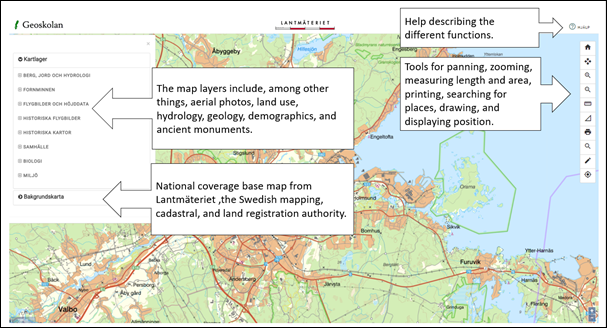
The Mapping Tool - a simple GIS
Geoskolan's web-based mapping tool can be described as a simple GIS, geographic information system, which allows analysis and presentation by:
- Selecting map layers,
- Zooming and panning,
- Finding location,
- Finding location information in the form of coordinates and elevation,
- Measuring, drawing and printing.
The tool includes up-to-date, nationwide map layers from several authorities, such as:
- Maps, aerial photos and elevation data from Lantmäteriet,
- Bedrock, groundwater and soil types from the Geological Survey of Sweden, SGU,
- Ancient monuments from the National Heritage Board, RAÄ,
- Population statistics from the Statistical Authority, SCB,
- Protected areas from the Swedish Environmental Protection Agency, Naturvårdsverket
- Watershed areas from Swedish Meteorological and Hydrological Institute, SMHI.
- Production and industrial facilities from the County Administrative Boards, Länsstyrelsen.
The map layers are directly linked to the various authorities' services, which means that the mapping tool always presents the most recently updated information. The map layers are nationwide, making it easy to adapt the lesson to the students' local environment.
The mapping tool is designed for desktop use, but also works well for field studies as it is adapted for smart phones and tablets.
Help and tips for Geoskolan's mapping tool (in Swedish)
How can I use Geoskolan?
Lantmäteriet's maps and images are protected by law
As a user of Geoskolan, you can:
- Make analog and digital prints of our maps/images at no cost.
- Publish our maps/images as illustrations in analog form, for example in reports, books, or similar.
- Publish maps/images in digital form if you add your own information on top and that information is primary.
Publishing in digital form is not allowed in any kind of commercial context, for example where published images are available for payment or on websites/e-services/apps that are funded by advertising or similar.