

Contents of this page may be automatically translated, we take no responsibility for the accuracy of the translation. Feel free to contact our customer support centre if you have any questions.
The service presents information about rights that is reported in the general part of the Real Estate Register. The product name in Swedish is Rättighet Visning.
About this product
The information is divided into two different layers:
- Rights
- Border point text, rights
See presentation of the information layers.
Maintenance and update frequency
The information is updated regularly by governmental and municipal Cadastral Authorities. Many older rights are missing in the Real Property Register, for example official easements, since before 1972 there were no requirements that they should be reported. For properties formed after 1972, all rights are registered. Official rights are registered in connection with the cadastral procedure.
Availability
Our geodata services are normally available 24/7 and we provide support during working hours. Read more about availability to geodata services.
Presentation of the information layers
Rights
The layer contains easements, right of user, utility easement, joint facility, road right, boundary for game conservation area and former border for kronomark.
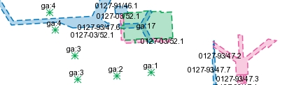
Sample image at scale 1:2,000.
Boundary point text, rights
The layer contains boundary point texts.

Sample image at scale 1:500.
Documentation
The versions of the services may overlap, so pay attention to which version you pick up at home. The version history describes the changes that occurred at each update.
| Version and date | Change since previous version |
|---|---|
|
Version 1.0 New versionAvailable 2022-05-02 |
New view service |
Technical framework and standard for view services
Our map and image view services are based on the standardized call interfaces Web Map Service (WMS) and Web Map Tile Service (WMTS) developed by The Open Geospatial Consortium (OGC). WMS is also an ISO standard (ISO 19128).
The Open Geospatial Consortium website (new window)
The services are of the nature 'question-answer', where the consumer (user's system) sends a service call over the Internet and receives a map image in a standard image format or in a vector format for certain types of services.
The characteristics of the map image are defined by the call parameters, such as information type, geographical spread, reference system, image format and image size.
There are many client applications for display services or components for integration into own system available. In addition to commercial products, there are a number of established products based on open source code, such as QGIS.
At OSGeo, The Open Source Geospatial Foundation you can read more about software in the field of geodata that are based on open source code.
Do you want deeper technical information about our geodata products you can read the product documentation.
Our geodata products with API:s require that you have an application or software capable of managing the services. To view real property information or maps directly in your browser, you can use Lantmäteriet's e-services.
Order product
You can order geodata products directly from us or from one of our resellers.
Order from Lantmäteriet
If you want to order directly from us at Lantmäteriet you should use the Order form.
To use our geodata products, you need a license for use.
In the order form, you can both order geodata products and apply for a license agreement.
Order from resellers
If you need help with ordering our geodata products or get a customized solution for your business, you can contact one of our geodata resellers.